Glenridding Circular
Walk Date – 21st January 2017
Distance – 5.2 miles
Weather – frosty but very sunny, no cloud, no wind
After a very dreich week up popped another sunny Saturday so I made the most of it and took another short walk over some of the footpaths which criss-cross the fellsides just above Glenridding.
Route
Roadside parking in Glenridding – Greenside Road – Rattlebeck Lane – Gillside – Westside – Keldas – Lanty Tarn – Grassthwaite Howe – Grisedale – path below Black Crag – Patterdale – St Patrick’s Well – Ullswater – Glenridding


Ahead of me is a rather chilly view as I walk out of Glenridding and up the Greenside Road towards The Travellers Rest. In stark contrast, Birkhouse Moor is aglow in the bright morning sunshine.

At the junction in the road I take the left turning and head down the lane towards Rattlebeck Cottage and the bridge just beside it. I expected to see hordes of walkers out on such a lovely day but there was hardly anyone around.

Glenridding Dodd across the sunny fields, and I’m now thinking that perhaps I should have walked up there today. I would have been walking in sunshine for the whole walk, whereas, the route I’m taking today will definitely take me into some very shaded and chilly areas.

A look back down the track from just above the Gillside campsite with Place Fell on the right skyline. Another person is on the track below me but he was walking his two dogs and was only out for a short walk with them.

A flock of young Herdwicks scratching around for beakfast in the field alongside the track. How do I know they are young Herdwicks? Because mature ones have grey fleeces. Don’t run away with the idea that I’m an expert on Herdwicks though, because the only other thing I know about them is that they are a very hardy breed and can tough it out in all weathers. Oh, and they have very cute faces too.

Just a little further along and I come to a wall corner and this sign. As I’m not going to Greenside or Helvellyn and I’ve already parked my car it didn’t have much significance for me.

What the sign omitted to tell me was where this path, to the left of the wall corner, would lead me to, so it was just as well that I knew where I was going. I’m going to be in the shade for a while from now on but at least the paths were firm and dry so I made good progress.

A view of a sunlit Glenridding as I make my way across the path.

The path begins to rise as it traverses the shaded and frosty fellside on the way over to Keldas. The path was very icy in places and the grass was slippy with frost so I took extra care across here, one broken leg on the team is quite enough to be dealing with without adding another one.

More of Ullswater comes into view as the path rises higher across the fellside. Surface ice on the water, bright sunny fields contrasting with white frosty ones and not a breath of wind anywhere. Its a really lovely winter’s day and its grand to be out in it.

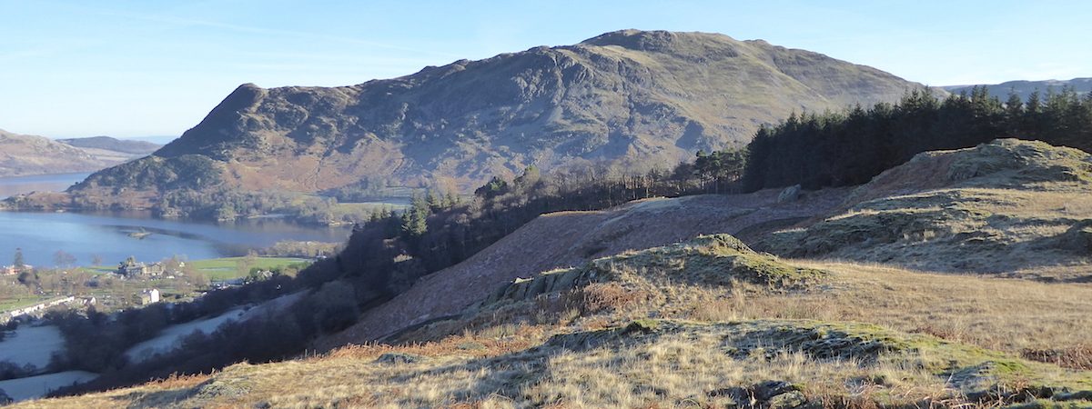
Looking across Ullswater at the steep profile of Birk Fell, one of the subsidiary tops of Place Fell.

Sheffield Pike and Glenridding Dodd are over on my left but I couldn’t see anyone making their way up either of them.

Well, this dead tree may have been uprooted in a storm at some time but it certainly had enough nourishment left in it to provide sustenance for an army of bracket fungi which were thriving and multiplying on every branch, each one playing their part as agents in the wood decay process and so doing their bit for the environment.

I’m much higher up now and Gowbarrow Fell appears beyond the bend of Ullswater. Gowbarrow is another possibility for a short walk for me whenever the next fine day arrives.

To my left from the same vantage point is the east ridge of Birkhouse Moor on the left, and Sheffield Pike over on the right.

From this point I made my way over to the little outcrop in front of the trees over on the right …..

….. from where I took this shot looking over Glenridding and across Ullswater to Gowbarrow Fell. The headland jutting out into Ullswater is Silver Point, the little islet opposite it is Norfolk Island and the other islet is Lingy Holm.

The sun is still blazing down on Sheffield Pike and Glenridding Dodd, and now that I’m getting some warmth too my jacket gets unzipped and my gloves can stay tucked in my pocket for a while.

Behind me paths criss cross the fellside, but if you were going to walk up to Birkhouse Moor you could just head for the wall on the left of the shot and simply follow it all the way up to the top.

I descended from my vantage point using the grassy path on the right, which brought me out right beside …..

…. Lanty’s Tarn, named after Lancelot Dobson, whose family owned much of Grisedale in the 18th century, and who lived in a large mansion near Grassthwaite Howe. The area is marked on the map but I could see no indication of where the mansion might have once stood as I walked though so nothing of their house seems to have survived.

The lack of even the slightest breeze provided some lovely reflections in the tarn.

Reflections in this directions were practically non-existent in this direction thanks to the film of surface ice.

I had the place to myself for a good ten minutes, so I just enjoyed the peace and quiet for a while before making my way back to the path, which runs just above the tarn over on the right.

Further along the path there is a dam wall. The Marshall family, who lived nearby at Patterdale Hall, later acquired the tarn and enlarged it by erecting the dam and using the tarn for fishing. They also built an ice house where they stored ice from the tarn for use during the summer.

The tarn from the dam wall.

Out into the sunshine again, and a look back along the path from the tarn which will lead me into …..

….. a very, very chilly Grisedale. The low winter sun does not rise high enough over Birks and Saint Sunday Crag at the moment, and won’t do for a while yet, so the valley remains in the freezer for the time being.

From the same spot, over to my left, are Angletarn Pikes on the left of the skyline, and Arnison Crag over on the right.

As I make my way down into the frozen Grisedale, over on my right the Helvellyn range is bathed is sunshine. The path I’m on continues straight ahead and then begins to rise across the fellside, eventually bringing walkers to the famed “Hole in the Wall’ where the Striding Edge path across to the summit of Helvellyn begins.

As I’m not going to Helvellyn I turn left off the path and make my way down the icy path to the gate at the bottom, where I will pick up the farm road and continue on into the bottom of the valley. My jacket is now zipped back up again and in the couple of minutes it took to do that, get the camera out and take the photo, my fingers were numbed by the icy chill and the gloves went back on sharpish. It is unbelievably cold down here.

Another envious glance at the sun on the Helvellyn range as I pick my way carefully down the very slippery path. I considered putting my spikes on but decided against, it was only a short distance and I couldn’t be bothered with all the faffing about.

Safely down to the valley bottom where a bleak looking Grisedale Beck gurgles its way down into Ullswater.

The farm road takes me across the bridge over the beck and meets up with the lane running along the valley bottom. When I reach the junction I turn right and then its just a few paces along to …..

….. this gate and the footpath beyond. This path goes to the right of the barn and then on up the fellside to meet another path which will lead me back to Patterdale.

As I begin the climb out of the valley I took a look across to see if the path I mentioned earlier, up to The Hole in the Wall, was visible but it wasn’t showing up very well amongst all the dead bracken so I can’t really point it out for you.

The path up the fellside from the barn eventually meets this one running along the fellside just above the valley bottom, and as I’m about to lose the view of the Helvellyn range I took a look back before leaving the valley behind.

The sunshine beckons me on as I crunch my way over the frosted grass towards the sunny fields above Patterdale.

Back in the sunshine once more so the jacket is unzipped again and the gloves are off. On my left is Keldas, the high point in the trees on the skyline.

From the sunny fields there was another section of gloom and chill along the lane going down to the main road running through Patterdale. There was a bit more light at this point so this shot shows the bridge carrying the road across Grisedale Beck.

The road wasn’t too busy so it was an easy crossing over to this footpath which runs alongside it, I’m now on my way back to Glenridding.

The footpath on the other side came to an end, so it was back over the road to pick up this one. A little bit of Ullswater is showing on the right of the shot. Just behind me a chap had pulled into a little lay-by and leaped out of his car clutching his camera. As we met he said he was so excited by the scenery around him he just didn’t know which way to point the camera first. ‘Kid in a sweet shop’ came to mind and it was lovely to see a grown man so overwhelmed and enthused by the beauty of the landscape around him. I hope he never loses that joy.

No doubt this view of Ullswater and Place Fell bathed in sunshine would be one of the sights he would have been pointing his camera at, and who knows, it could be a sight such as this which makes him say to himself, “I’m going to come back and climb up there.”

I’m back in Glenridding now but before returning to the car I strolled down to the shore, where there was barely a ripple on the water, and in which the vapour trails were beautifully reflected.

Similarly, to my left, Place Fell also had a mirror image in the unusually calm water. I haven’t seen Ullswater this flat for quite some time.

Making my way back to the car and crossing the road bridge over the beck which flows down from Red Tarn at the foot of Helvellyn. An enormous amount of repair work has taken place and things are gradually getting back to normal following the winter storms of 2015/16 …..

This is the same view on the morning of Sunday 7th December 2015 showing just how extensive the damage was after Storm Desmond.

There is still quite a bit to do to put the car park and the tourist information office back into operation on the other side of the beck, but its getting there.

The Glenridding Hotel has been given extra flood proofing, is now fully restored and re-opened for business at the beginning of December 2016.

The bridge is behind me, Glenridding Dodd is ahead of me, and my walk comes to an end as I walk back to my little red car, parked just behind the red van along there. Its just turned 1.00 pm and I’m beginning to feel hungry so I’d better get myself off home for something to eat. The patient resting his broken leg there will already have eaten his lunch because I left it all packed up ready to eat before I started out this morning, so he’s had a packed lunch and not been on a walk, while I have been on a walk and haven’t got a packed lunch. I think I got something a bit out of kilter there!