
Red Pike, High Stile and High Crag
Walk Date – 20th April 2016
Distance – 8.7 miles
Weather – warm and sunny, but hazy, south westerly breeze on summits
Route


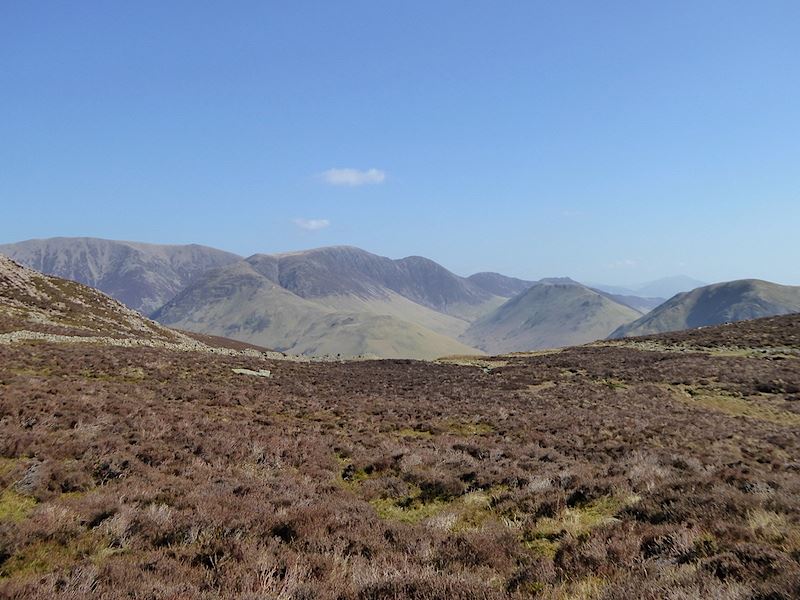
Its 8.40 am on a beautiful morning in Buttermere and we’re off to walk across the Red Pike to High Crag ridge, part of which is on the skyline opposite. The first fell of the walk, Red Pike, can’t be seen at the moment as its behind Dodd, the fell to the right of the shot. The gash in the fell side is Sour Milk Gill and our route will go up diagonally from the bottom left of that, through the trees and out onto the open fellside over to the left. The path will then turn back on itself and head up to the right to the top of the gill and on to Bleaberry Tarn. From the tarn the path leads up to Red Pike. Off we go then, down the hill from the parking area on our way into Buttermere and not a cloud in the sky, its going to be a good day.

St James’s Church, Buttermere where we parked out of shot just by the wall.

The start of the path through Burtness Wood. A good path but it seemed to go on forever, or perhaps I was just being a little impatient to get out of the woods and to able to see something other than trees.

At last we reach the open fellside and a chance to look across Buttermere village to the Grasmoor group of fells. Grasmoor is the big fell on the centre skyline. The triangular fell in the centre below it is Whiteless Pike, and below that is the long ridge of Rannerdale Knotts.

Turning slightly to the right and opposite is High Snockrigg which rises up to Robinson.

As the path turns towards Sour Milk Gill it levels out a little, from where there is this great view of Crummock Water with the Loweswater fells reflected in it at the far end.

A look back for a view of the path we’re on. Across Buttermere is Robinson, then Hindscarth and Dale Head with part of Fleetwith Pike over on the right.

The path turns up and runs parallel, more or less, with Sour Milk Gill, so another look back before we start climbing again.

Eventually we get our first glimpse of Red Pike, just peeping out over there on the left. Above Sour Milk Gill are the scree slopes of Dodd.

Looking up at Chapel Crags and Red Pike as we approach Bleaberry Tarn.

Bleaberry Tarn and the path leading up to The Saddle between Red Pike and Dodd.
Looking towards some of the north western fells from the tarn area.

The dramatic Chapel Crags above Bleaberry Tarn. There were plenty of midges over the water so the fish were very busy catching them for breakfast. Other than the occasional faint splash there wasn’t a sound up here. We had a short break here just enjoying the peace and quiet and watching the ripples made by the fish. It was tempting to stay a while longer but …..

….. the climb up to Red Pike was waiting, so it was on with the packs and off up the path to The Saddle.

A look back down the pitched path to Bleaberry Tarn, and a view of the path we followed up to the tarn.

Looking across The Saddle to Dodd. The pitched path swings away from The Saddle so we still have a firm footing at the moment.

A quick look over to Crummock Water and Grasmoor before continuing.

Turning round to have a look at what comes next. Yes, its steep but we still have a firm footing for the time being. Even so it’ll be hot work because the morning is warming up rapidly.

The pitched path comes to an end and we have to scrabble across the very loose scree and soil to reach the bottom of the gully. Well, the GPS gadget may have given us a total walk mileage of over 8 miles but just getting up here felt that far. OK, so I exaggerate but it felt like 8 miles worth of effort. This section will also have a pitched path very soon according to the notices which we kept seeing. As far as I’m concerned it can’t come soon enough.

A few minutes more scrabbling over the loose ground and we are on the summit of Red Pike, our efforts are rewarded with this fabulous view of Crummock Water and the Grasmoor fells.

The views from Red Pike summit are excellent, although the haze does rather spoil the definition on the fells. This is the view to the north east over Dodd.

There’s no-one else around and we take a short break in the summit shelter. It wasn’t too windy but there was a sneaky little breeze which the shelter kept at bay.
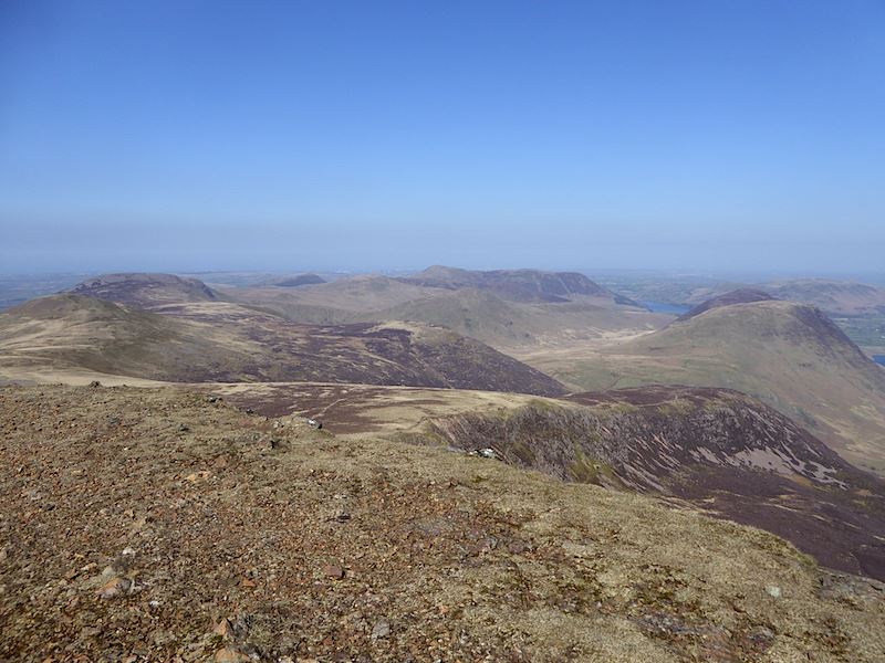
All the cursing, grumbling and sweating on the way up are forgotten the minute you hit the top and take in the fabulous views. Here I’m looking to the west from the summit. Over on the right of the shot are the two tops of Mellbreak with Loweswater just to the left of it. On the left the large, heather clad fell is Great Borne, with the lighter green and brown slopes of Starling Dodd just in front of it.

A closer look at Great Borne and Starling Dodd, with Ennerdale Water to the left of them.

The little white object in the centre is another one of the notices announcing the impending provision of the last section of pitched path up to the summit of Red Pike. On the skyline to the right of centre is Haycock leading down to the rocky lump of Little Gowder Crag and then on to Caw Fell.

Summit meeting. We had Red Pike to ourselves for about ten minutes before four other walkers arrived. Not a group, just a young couple, one lone male walker and one male runner, with the green head-band, who eventually set off towards High Stile like a scalded cat.

Summit cairn on Red Pike. Look at the trousers, told you it was windy.

The view ahead to High Stile, the hard climbing is done with but there are still a few ups and downs along the ridge.

The bald top of Bowness Knott sandwiched between Great Borne, on the right, and Ennerdale Water and Crag Fell on the left. You would have a view of the coast too but for the haze.

Leaving Red Pike and heading over to High Stile. The runner is long gone, the young couple are well on their way and the lone male walker is still back at the summit, the usual ebb and flow of fell walkers.

The view down to the tarn as we walk the path over Chapel Crags. The path up to the tarn on the right hand side of it, and the path leading over to Red Pike on the left.

Looking back to Red Pike from Chapel Crags.

On we go, climbing steadily up to High Stile.

A view of the tarn from one of the gullies on Chapel Crags. Its enough to turn the legs to a quivering jelly!

A slightly different view of the tarn from another deep and narrow gully further along the path.

Peering over the crags for a view of Red Pike, Mellbreak, Dodd and Bleaberry Tarn.

Crag Fell on the far side of Ennerdale Water, with Angler’s Crag, below it, jutting out into the water.

A glimpse of Robinson behind the crags on High Stile. The highest point of High Stile is just over there on that northern spur and is about three feet higher than …..

….. this high point cairn along the High Stile ridge.

Not being a pernickety stickler for standing on the absolute topmost inch of any fell, I can make do with a five minute sit down at this cairn. This cairn has a bit more about it than the one marking the higher point, which looks as though someone with a dumper truck has come along and just haphazardly off-loaded a heap of stones, with no thought of structure or appearance, so I didn’t bother taking a photo of it.

Just a few feet away from the cairn is this high point which gives a retrospective view of Red Pike and a good view of the scenery to the west.

From the cairn at 2644′ we walk around to the northern spur to the higher point at 2647′, taking in this view of Pillar across Ennerdale along the way.

A couple of shots as we walk across the spur …..

….. with dramatic views of Chapel Crags.

Unfortunately, when we reached it the best view point was occupied by walkers having their lunch, and short of trampling through their sandwiches and packets of crisps, there wasn’t much I could do about it. In any case, it didn’t matter very much as the views would have been more or less the same as the ones I’ve already taken.

On the eastern side of the spur, from left to right, are Dale Head, Fleetwith Pike and High Crag, nearest the camera.

Slightly to the left of the previous shot are Robinson, Hindscarth and Dale Head, with the long ridge of Fleetwith Pike over on the right.

Heading over towards the final fell of the walk, High Crag over towards the left of the shot.

Before dropping down to the High Crag ridge a shot of Haycock, on the centre skyline, with Little Gowder Crag, then Caw Fell to the right of it. To the left of Haycock are the ridges of Great Scoat Fell and Steeple.

A glimpse of the head of Buttermere as we cross over from High Stile to High Crag.

The crumbling faces of Grey Crags across Burtness Comb, the arrow indicating the position of two rock climbers.

A close up of the two climbers. I’m no rock climber, but even if I was I would be thinking twice about tackling such shattered and weather beaten rocks.

A look back at the route from High Stile across Comb Crags.

The head of Buttermere as we approach the crags of High Crag.

Not a great shot of Pillar but its the best that could be managed today. Pillar Rock is more or less visible between the two slivers of snow on either side of it. Over on the right skyline the pointed top of Steeple is now visible.

Comb Beck flowing down Burtness Comb and on into Buttermere.

Looking down into the very long valley of Ennerdale as we walk over to High Crag.

High Stile across Burtness Comb. I wondered how the two rock climbers were getting on on Grey Crags over there. They’ve already had to walk all the way up from Buttermere, with all their gear, just to get to the crags. Then comes the really hard work of doing the climbing, its enough to turn the legs to jelly just thinking about it.

High Stile across Comb Crags.

Looking down Gamlin End on High Crag to Seat, immediately below with the path along it. Haystacks is behind and to the left of Seat, with Green Gable and Great Gable on the right skyline guarding the head of Ennerdale.

Turning slightly left for a view of Fleetwith Pike across Warnscale Bottom.

A little more to the left and across Fleetwith Pike from left to right are, Robinson, HIndscarth and Dale Head.

A look at what’s before us before we step into thin air, or so it appears. On the right across Ennerdale are the lower slopes of Pillar behind which is Kirk Fell, with Great Gable to the left of it. Behind Kirk Fell, and just above the dip in the middle of it, is Scafell Pike, with Scafell to the right of that. The River Liza snaking its way along Ennerdale far below.

Looking back towards High Stile from High Crag summit cairn.

We have the summit all to ourselves, which makes me wonder where everyone else has got to. Perhaps they are all still on HIgh Stile eating their sandwiches and discussing whether they can face the steep descent off this summit.

We’re not really stepping into thin air, but its a very steep descent, as you can see, and the path, if I can call it one, is horribly loose underfoot. Part of it is visible on the left of the shot and, from there, it winds down and across to the right.

A bit more of the rough path at the bottom right of the shot, so carefully down we go. We were a little way further down, negotiating a tricky bit, when a young man came along behind us and asked us if we had lost a basket further back. We were a little nonplussed as neither of us had noticed a basket anywhere. We must have looked a bit bewildered as he then took out of his pocket one of those cup-shaped rubber things which can be attached to walking poles and are intended to stop the pole sinking into soft ground. Ah, that’s what you mean, I’d had visions of shopping baskets in my mind! Anyway we hadn’t lost one so off he went. He didn’t seem at all bothered by the state of the path, and by the time we reached the pitched section …..

….. he was way down there, on his way to the level section by the tarn. Ah, the carefree confidence of youth, and where does it go when you get older? This path is firmer under foot but its steep and twisty and if you don’t keep the brakes on you can find yourself being propelled downwards by what feels like an invisible force. I think its called gravity. Anyway, if you aren’t careful you end up feeling like a runaway train and descending a whole lot faster than you might have intended.

We needed to get back to Buttermere village so we left the main path, which carries on over Seat, and cut across to join the path coming down from Scarth Gap. Here’s a look back up at HIgh Crag while we waited for the leg muscles to recover.

We eventually join the Scarth Gap path, the legs return to something like normality and we can enjoy the pleasant wander back down to the shore-line path along Buttermere.

Looking across Warnscale Bottom where Fleetwith Pike dominates the view …..

….. and ahead to Buttermere, where we are just about to join the shore-line path and where, at last, we can take the brakes off the legs and let the muscles really relax.

Its now a lovely afternoon, just the thing for the pleasant return stroll along the lake shore.


The gurgling and splashing sounds coming from Comb Beck were getting nearer and after taking this shot we stopped at the beck and had a short break, where we indulged in some blissful foot spa treatment, the first paddle of the year, in the very, very cold water. A treat for feet.

The breeze still ruffling the waters of Buttermere.

We reach the end of our walk as we cross the fields between Buttermere and Crummock Water, so I take a final look along the water to Fleetwith Pike. We decided that we owed it to ourselves to have an ice-cream from Wilkinsyke Farm, its made on the premises and, in our opinion, is the best ice-cream in Lakeland. What better way to end a grand day out?