
Sour Howes and Sallows
Walk Date – 9th July 2015
Distance – 8.2 miles
Weather – dry, cloudy start, brighter later, light northerly breeze
Route
(the outward route is in red and the return is in blue)


The Garburn Road at the start of the walk.

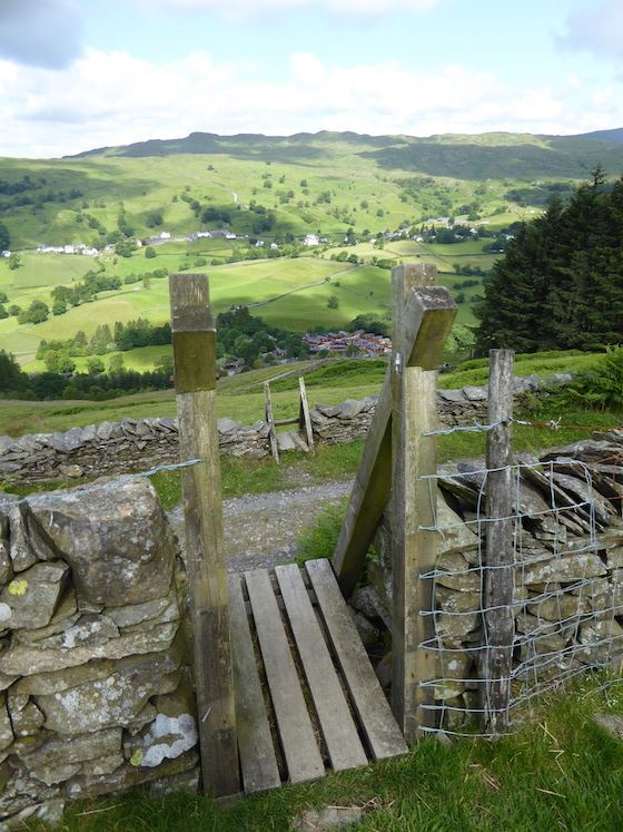
Higher up the path the view opens up and we see the lovely Troutbeck Valley.

We leave the Garburn Road via this stile and make for the next stile in the far wall over to the right.

A view of Wansfell beyond Troutbeck, the stile we have just used is down at the lower right corner of the photo.

The long …..

….. and the short of it at the second stile. We’ve left the Garburn Road down below and we are now on the Dubbs Road.

Immediately behind us is a third stile, once again, long on this side …..
….. and very short on the other. I was hoping to get all three stiles in the shot but didn’t so these two will have to do.

Climbing the hillside from the stile in the previous photo with the Troutbeck Valley over to our left.

A close up of Dubbs reservoir which was over on our right, we’ll be along there later on.

A view up to the summit of Sour Howes.

The Dubbs Road continues along down there just beside the trees, The high fell on the centre skyline is Red Screes which is just beginning to come into view.

The light went out on Wansfell for a while so I zoomed in on the Scafell range in the distance.

The Coniston Fells.

The light got switched on again over Troutbeck which afforded a better view of Wansfell. Nanny Lane on the left looks different, new surface maybe.

Windermere, it makes a change to have a decent view of it for once.

A close up of the southern end of Windermere.

Getting closer to the summit of Sour Howes.

Approaching the top of Sour Howes.

A very welcome sit down on Sour Howes summit.

A close up of some old quarry workings which I noticed opposite us on the lower slopes of Sallows.

From Sour Howes a view of the western section of the Kentmere Horseshoe, Yoke on the right, then Ill Bell and just visible behind Ill Bell, the peak of Froswick.

Over on the left of the skyline is Red Screes, with Stony Cove Pike under some cloud over on the right. From this viewpoint it looks as though you could stroll across from one to the other, but you can’t because the Kirkstone Pass runs between them.

We’re now making our way over to Sallows. No great navigation skills required as its simply a matter of following the wall.

Wall work in progress. Flask at the ready, a radio for company. Nice day at the office.

I take a look back at Sour Howes as we follow the wall round to Sallows.

Across the stile en route for Sallows we pause for a look over at Red Screes and Stony Cove Pike.

The rather unimpressive top of Sallows, the views make up for it.

A view of the path up to Yoke from the top of Sallows.

Sallows summit mound.

From Sallows top looking over at the eastern part of the Kentmere Horseshoe. Shipman Knotts with cloud shadow, then Kentmere Pike and well over on the left is Harter Fell.

Yoke on the left and Harter Fell over on the far right.

Back down to the Garburn Road now and a look back at Yoke before we leave.

We have a view of the Coniston Fells all the way down the Garburn Road.

We left the Garburn Road at the junction and continued along the Dubbs Road, on the left is the route we took up to Sour Howes earlier.

A look back along the Troutbeck valley, the scene constantly changing as the clouds moved over the landscape.

We’re a good way along the Dubbs Road now and approaching Dubbs reservoir.

It wasn’t possible to get any closer, there were lots of ‘Keep Out’ notices, dire warnings about adders on the loose and a group of United Utilities employees on site just over to my left. Training course size group I would think. Of course we wouldn’t ever have thought of trespassing even if all of the above restrictions hadn’t applied, now would we?

From Dubbs we walked over to Borrans reservoir where there were no keep out signs, just notices reminding people not to swim, much better approach I thought.

Not much activity at the Borrans Activity Centre.

Not as qiuet and peaceful at Borrans as you might think …..

….. it was ‘head ’em up and move ’em out’ time. Non stop shouts of ‘gerrup ower theer’ and ‘gerr’arn’. Wonder if the men will have any voices left tomorrow?

The sheep have been gathered in and peace broke out again, here I’m looking over the reservoir towards Sour Howes.

The dam wall of Borrans reservoir, with the overspill channel on the right of the picture.

No, she’s not stuck, she’s just having a scratch. I think that fleece ought have been sheared off by now.

Having sorted out the neck area she moved on to deal with the back. The fallen tree stump is so well used its surfaces have been rubbed smooth.

Another look at the Scafell range, with the Langdale Pikes on the right, as we walk back along the Moorhowe Road. The verges, bankings and hedgerows contained a staggering variety of colourful wild flowers, wild roses, meadow sweet, buttercups and so on, most of them I didn’t know the names of, but the scent of them in the light breeze was lovely. The views of the fells in the distance were an added bonus.

Here we are, back in Troutbeck exactly six hours after we left it. A good walk, no crowds and in some lovely countryside, on a very fine day. A little less breeze from the north would have been preferable, but I’m not complaining, the sun was out and it didn’t rain, you can’t ask for much more than that.