Clough Head
Walk Date – 4th June 2016
Distance – 5 miles
Weather – warm, overcast, hazy
Route


The good weather continues so once the morning jobs were done we decided to have an afternoon walk up to Clough Head via the Old Coach Road. The road begins where I am standing and we have parked just at the beginning of it where it joins the A5322, which is the tarmac road in the foreground. The view is of Skiddaw on the left with Lonscale Fell over to the right. Long distance views were difficult today, it was very hazy so nothing showed up particularly well.

From the same spot I turned round for this view of Clough Head beyond the trees in someone’s garden. The Old Coach Road is veering off to the left and is a rough stony track which leads over to High Row, near Dockray.

Further up the road and more of Clough Head appears on the skyline.

We’ve passed through the small area of forest now and we’re out onto the open fell side with Lonscale Fell on the left and Blencathra to the right. Judging by the style of the seat it has been here quite a good number of years.

Standing on the road just below the seat I take a look back at High Rigg, on the left, with Low Rigg on the right.

Continuing on up the road towards the spoil heaps and old quarries. This lower area is called Threlkeld Knotts, which in the past was quarried for the granite it contained.

Further along the road and a look back to Latrigg, the small fell on the left, with the Skiddaw fells over to the right.

The long and winding Old Coach Road stretching ahead of us with more evidence of past quarrying on the fellsides.

A look back to Blencathra with the village of Threlkeld nestling below it. I took to walking on the grass as the rough stony track was beginning be a nuisance. The stones and pebbles have a habit of sliding away just as you push off against them, at best it slows you down and at worst you end up with grazed knees.

The winter storms haven’t helped either and in many places the road has been badly damaged by all the water which flowed down it. This particular groove was easily 2′ deep and on the gate up ahead …..

….. was this notice. There was a similar one on all of the gates we went through as it is not traffic restricted and vehicles can still be driven along here. Driving along this road in a modern vehicle would be uncomfortable enough, even without all the damage, what it was like sitting in a horse drawn coach you can only imagine and wince.

From the gate a look back at the badly damaged road and the sheepfold just beside it.

A close up of the sheepfold, named on the OS map as Clough Fold, which is so well maintained that it must still be in use.

I had just taken the previous shot of the sheepfold and was about to put the camera back in the bag when I saw this convoy of 4×4’s coming along towards the gate so I took a close up shot of it. The drivers have ignored the notice on the first gate, which was just a little way up from where we had parked, and decided to risk it. Astounded is a nicer word, but gobsmacked better conveys how I felt when I saw them. They had to stop when they were almost at the sheepfold and the drivers began getting out to have a look and discuss the situation. We left them to their deliberations and carried on with our walk.

We’re now almost at the top of the climb out of St John’s in the Vale and the Mell fells appear on the horizon.

The road carries on to High Row, but we leave it here and begin the steepish climb up to White Pike. Just below the fence to the right is the roof of …..

….. an old railway goods wagon which seems to have been used for storage or shelter in the past. Its now quietly falling into decay.

Its time to get the legs into bottom gear and make the climb up to White Pike which is over there on the left. Its a well trodden and firm path, not excessively steep, but it definitely gives the legs and lungs a good workout.

Pausing for a breather and a look back down at our route, and the goods wagon, from the road.

I’m just about to put the camera away when I get gobsmacked again. Thirty two minutes have elapsed between this shot and the previous one of the convoy so it has taken them quite a while to negotiate the rough track up to this point, and they still haven’t reached the gate where we turned off.

We watched their painfully slow and bumpy progress wondering all the while, why? Why would you drive over such a horrendously damaged track, risking damage to your expensive vehicle and possibly yourself, whilst grinding along at a snail’s pace in bottom gear and using heaps of fuel? Perhaps its a ‘bloke thing’.

We’ve seen enough so back to the matter in hand and we are soon approaching White Pike, up there on the left.

From the slopes of White Pike a look across to Great Dodd on the right and the long sweep down which ends at Wolf Crags on the left.

Still on the little col between White Pike and Clough Head. The path over to the right is the one we will take up to Clough Head summit.

A look back at White Pike from the climb up to Clough Head. I expected to see the convoy on the road below over to the right but they still hadn’t made it that far, so they were still somewhere below White Pike. I couldn’t be bothered to wait so I didn’t see them again as we carried on to the summit.

A view down to Threlkeld Knotts and St John’s in the Vale as we approach Clough Head summit.

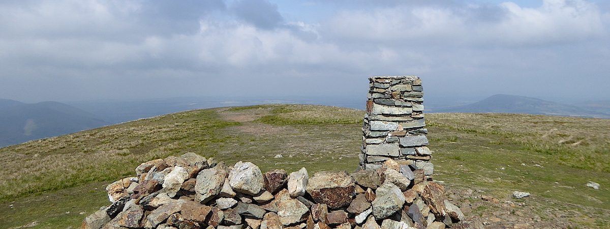
The trig column and shelter come into view on the pleasant stroll across the top.

On a better day the views would be lovely from Clough Head summit.

Behind the trig column and shelter is Blencathra.

The blue-grey view eastwards from the summit.

At least we can see Latrigg, the little fell over on the right.

One last shot at the summit and then we’ll go, the sun is out but the haze isn’t shifting at all.

We start the descent and on our left is Great Dodd again, this side of it slopes down to that little rocky bit which is called Calfhow Pike. Beyond the slope is Helvellyn which you can just about make out in the murk.

Calfhow Pike is now on the left and from it the land drops down and ends abruptly above some very steep crags.

A close up and hazy view to the north-western fells across Derwentwater from the descent.

A longer view of our descent route, we won’t drop off the edge though as the path veers off to the right and leads us across some scree slopes and then down to Threlkeld Knotts again.

This cairn marks the point where the path veers to the right across the slopes known as Red Screes.

These steep slopes mark the end, or the beginning, of the Clough Head to Dollywaggon Pike line of fells, usually referred to as the Helvellyn range, since Helvellyn, which is the highest of them, is situated towards the southern end of the range.

Sections of the path were very dry, dusty, loose and slippery as we haven’t had any serious rain for quite while now.

A look back at one of the trickier sections of the path, quite a steep slope with lots of loose stones beneath your feet but we managed to avoid any undignified slithers to the ground.

The view across St John’s in the Vale from the scree slope path.

High Rigg across the Vale with the Bleaberry Fell ridge behind it.

A look back at the descent route which started at about the middle of the grassy area of the centre skyline and continued down on the diagonal towards the left. It then curved around the grassy slopes to the point where I am now standing.

A look across to Wanthwaite Crags from the descent.

The gradient has become easier on the knees and becomes a pleasant stroll back down to the valley bottom.

Through the gate …..

….. over the stile …..

….. through the woods and along the forest track …..

….. and here we are back at the seat.

From the seat its a short walk back to the car which is parked just beyond those trees to the right of the shot. The ridges and folds of High Rigg seem more pronounced than they were to begin. A good little walk on a sunny Saturday afternoon, with a little convoy interest thrown in for good measure, you never know what you will come across when you go out for a walk.