
Great Crag and Grange Fell
Walk date- 16th June 2023
Distance – 4.5 miles
Weather – hot and sunny, very little breeze, fair weather cloud, hazy
The sunny dry spell continues so we opted for a short morning walk today to take advantage of the relatively fresher morning conditions and avoid the afternoon heat. We didn’t stray too far from the location of our previous walk to Bleaberry Fell and High Seat and instead of parking up just above Ashness Bridge we carried on up the road to our start point at Watendlath from where we would go over to Great Crag and then back across to Grange Fell. These two fells, as was the case on our previous walk, have notoriously boggy sections around them and we thought that these would now also be dry enough for us to experience the opportunity of a squelch free walk across them just as we did between Bleaberry and High Seat. On that walk report I mentioned that neither of us could remember the last time we had rain but now we can, it was on Sunday 11th June. Huge rain clouds arrived and dropped their contents on us for about 15 – 20 minutes after which they moved on and the sunny weather appeared once again. About two inches of rainwater had collected in an empty plastic planter I had left out in the garden so it was quite a downpour. Since then nothing, so its back to watering by hand.
Route
Watendlath – Watendlath Tarn – Great Crag – Dock Tarn – Puddingstone Bank – Grange Fell – Puddingstone Bank – Watendlath


All was quiet at Watendlath when we arrived at the National Trust car park. The toilets and cafe were not yet open and there wasn’t a soul to be seen anywhere. I think we arrived sometime between 8.15 and 8.30 am and ours was the only car in the car park. J had a bit of a hitch with the gps when it was switched on but it turned out to be something and nothing in the end. The usual method of switching any device off and starting again put everything back to rights again. Anyone thinking of hiring a boat and doing a spot of fishing at the tarn should note that the fishery is closed at the moment, due to the low water level I think. A very slight but refreshing breeze ruffled the water as we walked from the car park towards the old bridge across the tarn’s outflow. The outflow level was also low so we had no need of the bridge and simply stepped across the exposed stones in the dried out bed.

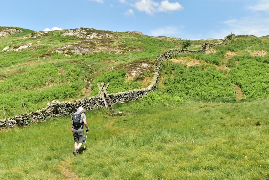
We followed the track beside the tarn from which it eventually turns away and then rises steadily across the hillside. The established grit and stone path eventually comes to an end at this beck, bone dry today but which usually has plenty of water running down it which originates in the marshy area higher up. Here we bear left and follow the grassy path around the slight rise seen in the shot.

Great Crag is over on the right as we cross another almost dry beck and begin to follow an established path which has been laid specifically to avoid damage to the plants in the marshy green area below the crag. This is usually a very wet crossing as the laid path is always running with water too, but not today so we enjoyed another novel experience and emerged by the gate in the wall with dry boots.

A look back at the skyline which shows, from left to right, Ether Knott, a distant Skiddaw and Lower Man and High Seat. Worthy of mention too is the bone dry path.

Looking ahead we are just about to pass through the gate and begin the steep climb up the stone stepped path towards the summit of Great Crag. There is also the option of bearing off to the left just beyond the gate on a path which leads directly to Dock Tarn, that’s the path we used for our return to the gate.

A look back towards Watendlath and its tarn sitting snugly below High Seat from some point along the steep climb. I can’t remember if we had stopped for a breather at this point or if we were about to divert from the main path and climb up to the summit via one of the paths going off to the right of it. Anyway, whichever it was we eventually reached …..

….. the summit of Great Crag, although it might be more accurate to say ‘summits’ since there are two high points which each have a cairn on them. Here the view is looking towards to the slightly higher, according to AW, south cairn from the north cairn, although there’s only a couple of feet difference between the two. The ‘pimple’ on the distant and hazy skyline just behind the south cairn is Pike O’Stickle.

The view looking north, from the north cairn, where Ether Knott and the Skiddaw group behind it have a cloud ‘tiara’ drifting gracefully above them.

From the north cairn a path leads over to a viewpoint from where I took this shot of Rosthwaite village down there in Borrowdale.

Above the village the skyline shows Pillar, over on the left, Dale Head on the right with the merest hint of Honister Crag (Black Star) just beginning to appear between them.

A little further to the left we have Great Gable, Green Gable, Brandreth and Grey Knotts. Pillar is now over on the right.

We crossed over from the north cairn to the south one using the path winding its way through the heather over there on the north top. Its obviously not a huge distance so it doesn’t take long to cross from one to the other. The very slight breeze we had down at the tarn as we started out seems to have vanished so there’s no air movement at all now. Here’s a few more views from the south top …..

….. smack dab in the centre is Combe Head on Glaramara with Bessyboot (Rosthwaite Fell) immediately below it, although it is difficult from the photo to separate the two, flanked on the left by Bowfell and on the right by Great End …..

….. over to the south east now with a view of High Raise and Pike O’Stickle on the skyline with the shadowy knobbly summits of Eagle Crag and Sergeant’s Crag across the middle foreground …..

….. even further to the left are Low and High Saddle on Coldbarrow Fell with Ullscarf taking up the right skyline. We get our first glimpse of Dock Tarn too which reminds us that we’ve been loitering on these two tops now for some time and we ought to be getting a move on.

We dropped down from the south top via one of the many paths which snake their way through the mass of heather and made our way over to Dock Tarn. The tarn sparkled and glinted as the sunlight hit the tops of the ripples created by a very slight breeze as it passed over the tarn’s surface. We weren’t getting any of that air movement at all as we walked along the path and it was like being in a hot oven along here.

Water lilies, not yet in bloom but it won’t be long until they are, on Dock Tarn.

Almost at the end of the tarn now and the area beyond it known as Green Combe. This was as far along the tarn as we went so we turned around and looked for a suitable spot to park ourselves and get the chocolate bars out. It was a bit early for a refreshment break but as it was now getting very warm we were concerned about them melting, we caught them just in time. As we were sitting there beside the path a couple of ladies came along from the Lingy End direction, as they passed by us one of them apologised for walking along in her underwear. Not that she had fully stripped down to her briefs and bra but she explained that she had taken her t-shirt off because the weather was so hot and couldn’t stand wearing it any longer. J couldn’t have cared less what she was wearing and I thought, in purely practical terms, as is my nature, that going for the next size up might have been more in keeping with the point of wearing a bra in the first place. Dumplings boiling over came to mind. Another pair of walkers came along shortly after and that was the sum total of people we met until we returned to Watendlath.

Having got ourselves upright and walking again after our break we returned to the gate in the wall via the path mentioned earlier and after passing through it more or less immediately veered off the paved path and headed left across the next usually marshy section towards Puddingstone Bank and Grange Fell. Apart from one tiny spring bubblng up from the ground and going nowhere the walk across was completely dry. There being no shade at all across here and out in the open with the sun on our backs it felt as though we were being slowly cooked in a very hot frying pan.

J passes through the gate in the first wall after which, and a good distance beyond this one is the gate in the second wall at the top of Puddingstone Bank.

By the time we reached the afore mentioned gate above Puddingstone Bank I was slowly turning into a melting jelly. I’m not that comfortable with too much heat, the beaches of the Mediterranean are not for me at all, and I could have done with some shade and a cold drink at this point. Well, looking ahead shade is off the menu unless I huddle beside the wall like the sheep do, and although we did have lots of liquid to drink by now it was warm enough to wash your hands in so drinking it didn’t cool me down either.
After a brief stop at the gate to take some warm liquid on board we set off up the slope heading for the stile crossing and the path beyond.

The view back towards Ullscarf and Great Crag after the stile crossing …..

….. and the lovely view across to the Borrowdale fells as we begin the last part of the climb up to the summit of Grange Fell. I was struggling to put one foot in front of the other by this time and mentioned to J that I was running on empty. Me and heat are not good companions but with lots of brow mopping stops and plenty of liquid I eventually made it to …..

….. the top where I could flop down, have a bite to eat and indulge in a relaxing break. Having got myself together again I reached for the camera and took my usual ‘views from the summit’ shots so here they are. To the southwest, beyond the summit crags, Great Gable takes centre stage …..

….. Great End on the centre skyline …..

….. Ullscarf and High Raise …..

….. King’s How is the view below us with Maiden Moor as a backdrop …..

….. to the north, Derwentwater and the Skiddaw group …..

….. to the east across Watendlath Fell are Browncove Crags, Helvellyn Lower Man, Helvellyn, Nethermost Pike, Dollywaggon Pike and Fairfield …..

….. White Side and Raise to the left of Browncove Crags …..

….. Watson’s Dodd, Stybarrow Dodd, White Side and Raise …..

….. High Seat, which we visited a week ago …..

….. Dale Head and High Spy …..

….. and finally, Great Gable, Green Gable, Brandreth, Grey Knotts and Dale Head. Great Crag and Grange Fell may not have the commanding heights of their neighbours but they certainly punch well above their weight in terms of their summit views.

The heat is intense now so we made our way back to the Puddingstone Bank path and then walked down to Watendlath with …..

….. a glance over to Great Crag and below it the ‘frying pan’ we walked across on our way to Grange Fell.

Almost back down to Watendlath, after a walk down in baking hot sunshine, and I’m keeping my fingers crossed that the cafe will be open so that I can have a cold drink at last.

Back at the tarn and the path we set out on earlier this morning. Its much too hot to do anything now, even the beach area where people usually sit is deserted. We stowed our stuff into the car boot and as we did so a couple trying to operate the parking meter called out to us. We went over and they told us that they couldn’t get the machine to recognise their credit card. We knew that the cafe often has problems taking payment by credit card as there is rarely an internet signal to make their machine work and therefore they can only take cash. Realising that the machine could not operate without the internet signal we told them that we were leaving soon and that they could have our parking ticket which still had plenty of time left on it, not that anyone from the National Trust would be coming up to Watendlath to check anyone’s tickets. If they come up once a plot to empty the machine of any cash I’d be surprised. We also mentioned to the couple, who might have been either German or Austrian judging by the language they used between themselves, that if they intended visiting the cafe that the same problem would arise and to make sure they had enough cash to cover their purchases. They thanked us quite a few times for helping them and I think they were also quite relieved to know that their credit card wasn’t the source of the problem. After all that I was more than ready for a sit down in some shade and drink a can of something very cold so off we went to the cafe and joined everyone else doing exactly the same. We chatted to the chap serving in the cafe about the lack of internet and he mentioned that he’d ‘telled ’em aboot it but they ne’er do owt, so a’ve gin ower botherin, they nivver come up anyway so a’ve stopped werryin’. The German/Austrian couple also used the cafe and eventually came into the garden with a tray laden with their purchases giving us a wave and a smile as they made their way into their own shady corner of the garden. A very pleasant way to end today’s walk we thought.