
Grisedale Pike, Hobcarton and Hobcarton End
Walk Date – 9th January 2019
Distance – 5.1 miles
Weather – very cold but dry and sunny, very light breeze on tops
The forecast for today looked promising. After a hard overnight frost there would be a cold, dry day with sunny spells, light winds and excellent visibility. That looked to be pretty much the same forecast as we had for our last walk and look how that turned out. Still, being the jolly little optimists that we are, we put our trust in the Met Office once again and decided that it would be a good time to pay Grisedale Pike another visit. Its getting on for four years since we walked up there, clad in shorts and t-shirts on a warm and sunny in June 2015, how quickly the years slip by. Well, there would be no shorts and t-shirts today, not for us or anyone else because the Met. Office got its tea leaf readings correct and thus its forecast came to pass.
Route
Revelin Moss – Hospital Plantation trail – Grisedale Pike’s north east ridge – Grisedale Pike – Hobcarton – Hobcarton End – Black Crag – Whinlatter Forest trail – Revelin Moss


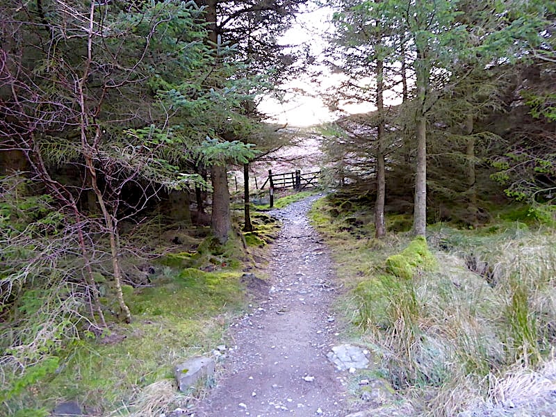
On the way up out of Braithwaite we were down to single file traffic where a new and more substantial wall was being installed alongside Coledale Beck just above the village. Hopefully this will save the village from further flooding should there be any more events as disastrous as Storm Desmond. We parked up, out of shot to the right, at the Forestry Commission’s parking area at Revelin Moss just above Comb Bridge on Whinlatter Pass. The gate in the shot marks the start of today’s round trip and we will return through the one which is slightly below this one, again out of shot on the right. As we’re only going to Grisedale Pike today we’re following a slightly longer forest route alongside Grisedale Gill below Hospital Plantation and making our way towards the crossing over Sanderson Gill. If you’re in a hurry the lower path just mentioned provides a shorter and more direct route to Sanderson Gill. Up the hill and over to the left, as you look at the shot, is a third gate which will take you through Hospital Plantation over a higher path. We used that route years ago which I remember as being quite rough and ending abruptly at the forest fence, which we then had to clamber over and climb steeply up to join the Sleet How path.

The parking meter was out of action, it wouldn’t take coins and the card payment slot did nothing but display ‘Please wait’, we waited but nothing further was displayed so the extortionate amount required for our short stay remained in our pockets and we went on our way with an even greater spring in our steps. Frost is everywhere as we walk in the deep, cold shade alongside Grisedale Gill with this sunny view of Grisedale Pike up ahead of us.

We arrive at Sanderson Gill where a slight geographical inexactitude occurred. I walked a little way across for this shot of it, and having done so we should have returned to the track showing to the left of the shot. We didn’t. I put the camera away and, completely forgetting about turning back, we just kept going for a few minutes along this track I’m standing on here. The penny dropped eventually and we did the required U-turn and came right back here again. Duh!

Back on track and just a very short way further along are these two waymarkers. The shorter one indicates a cycling route, the taller one indicates that the route for Grisedale Pike is off to the left …..
….. and this is what its pointing towards. At the end of the short path we go through the gate in the shot and immediately turn right to pass through another gate where …..

….. the very steep, and today very frosty, climb up to Grisedale Pike begins.

You could be forgiven for thinking that, from this look back to the gate, that there has been a fall of snow but there hasn’t, its just a very thick layer of frost which made for a slip-slidy climb across here.

A look back at the Skiddaw group and Blencathra as we labour up the steep slopes. You could say that the little hill below marks the end of the very, very steep climb up from the gate, but its quite obvious that the gradient hasn’t lessened all that much so its still a very hard slog.

We toil ever upwards and across the broken wall the skyline shows the various humps and bumps of our return route over Hobcarton and Black Crag. Despite the chilliness I’m now very hot so off comes my jacket …..

….. and J takes a moment to view the panorama to the east as he waits for me to join him. The summit of Grisedale Pike is in view on the skyline just to the right of him. He’s still wearing everything he started out in and even with this steep climb he still isn’t overheating. I don’t know why he doesn’t seem to get as hot as I do when wrapped in all that gear. He calls it being ‘nice and cosy’.

A pause for a breather as we climb higher and the views start to open up more. In the middle foreground is Hospital Plantation covering the slopes of Kinn, beyond which peeps the Vale of Keswick, bordered on the left by the Skiddaw group and Blencathra, and on the right by Clough Head and Great Dodd. The little pimples in the middle are the Mell Fells.

The gradient eases slightly along this section so the legs get a little light relief for the time being. Over on the left is the slope of Sleet How rising up to the summit of Grisedale Pike and we are beginning to see a few walkers silhouetted against the skyline as they make their way up it. The long slope to the right of the broken wall is our return route over Hobcarton.

Keswick and Derwentwater appear above the slopes of Kinn as I take a look eastwards. Earlier I mentioned we had once walked a higher path through Hospital Plantation which can be seen quite clearly in the shot. Its the one closest to the ridge ending at the forest fence and from where we climbed up to join the path over Kinn.

There’s not much heat from the sun and its having no effect on the frosty conditions at all but nevertheless its a lovely day and the clarity of the air gives us a well defined view of the Skiddaw group. Its great to see some detail again instead of a blue-grey blob and its a grand day to be out and about.
Turning slightly to the left and we have a view across Whinlatter Fell to the treeless top of Lord’s Seat with the isolated fell of Binsey in the distance behind it.

Another stop, this time to put my jacket back on. We are nearing the summit and are beginning to feel just a hint of a chilly breeze. Its nothing much but its enough to cool you down quite quickly and I didn’t want to lose any body heat. Apart from the spots on the shot, which I couldn’t get rid of despite wiping the lens clean a couple of time, its a marvellous view to the east. Immediately opposite is Kinn, then Outerside dropping down to Barrow followed by the unmistakeable Causey Pike. The skyline stretches from Clough Head to Fairfield and below it is Walla Crag and the Bleaberry Fell/High Seat ridge. The walkers I mentioned earlier are still plodding steadily up Sleet How, pausing often for a breather and no doubt to take in the views, and we are doing exactly the same thing over here. Fell runners will no doubt take a run up Grisedale Pike and back before breakfast and think nothing of it, but we ordinary mortals can only plod steadily up the long steep climb to the top whichever route we take.

We reach the top of Grisedale PIke where half a dozen folk were standing around, deep in conversation with each other about their various dogs . Not having a dog to talk about I turn my attention to the views. Firstly to Hobcarton and our route of descent …..

….. then over to my left where the pointed summit of Hopegill Head immediately catches the eye, as does the thick crust of frost which is layering the summit area.

Here I’m looking down towards the Kinn/Sleet How route up to the summit, the Coledale valley is below us with the shady slopes of Barrow to its right.

Looking south eastwards for a closer look at the layers of fells on view below the lovely soft light. Zooming in cut out a lot of the very bright sunlight and blue sky which resulted in a much softer and more atmospheric shot. The skyline view is extensive beginning with Harrison Stickle, on the extreme left, followed by Pike O’Stickle, then the bumpy ridge line of Glaramara behind which Wetherlam can just be seen through one of the ridge gaps. Just visible behind Dale Head in the centre is Swirl How followed by Bowfell, Esk Pike, Great End, Scafell Pike and Scafell.

Immediately below us is Barrow, behind it is Causey Pike and the ridge across Scar Crags, then comes Maiden Moor and High Spy, and on the skyline are Ullscarf, High Raise, Harrison Stickle and Pike O’Stickle.

Another zoom to bring the skyline view of the Dodds, the Helvellyn range together with Fairfield and Seat Sandal a little closer into focus.

Finally looking east across Barrow and Derwentwater where Clough Head, Great Dodd, Watson’s Dodd and Stybarrow Dodd are on view.

The conversation concerning dogs and their various idiosyncracies has come to an end, their owners have gone their respective ways, we have the summit to ourselves and I can get the shot I’ve had in mind from the start. There’s nothing by way of a cairn but one isn’t really necessary because you know well enough when you top out on Grisedale Pike. There isn’t a single thing left to climb up and from hereon the only direction is down. The views are fabulous wherever you look and walkers who haul themselves up here are well rewarded for their efforts. Immediately behind the summit in this view is Grasmoor, to the left is Crag Hill, or Eel Crag if you prefer that, with Sand Hill and Hopegill Head on the right.

We dropped down a short distance from the summit to find somewhere to sit and have a break for ten minutes or so and found a sunny little spot in a little dip about a hundred yards or so from where I’m standing.

Once we were settled into our little sunspot out came the sandwiches and hot soup. As we tucked in walkers were passing along the path in front of us, some descending, towards Hobcarton Crags and Hopegill Head or Coledale Hause, others were heading up to the summit. One of these, a chap of middling years walking alone and sweating profusely, asked us if what he could see ahead was indeed the summit or was there more climbing after that. We assured him that that was it to which he replied “Thank God for that”, mopped his forehead and set off with renewed enthusiasm. All walkers will have experienced that ‘will we ever get to the top’ feeling as they meet one false summit after another, especially when the legs are beginning to tire and they just will not get out of bottom gear no matter how hard you try to persuade them. His reaction made us smile but he had all our sympathy too.

Looking south east again from our little sunny spot. The Causey Pike/Scar Crags/Sail ridge just immediately opposite, a beautiful sky above and that wonderful skyline in the distance, viewed with hot soup and a beef sandwich. If anyone had asked me at this moment if there was anywhere else in the world I would rather be I would have given them an emphatic reply – No!

Having gazed over at Hopegill Head during our stop we talked about carrying on over to it and descending from it down to Ladyside Pike and returning to the car via that route. We still had plenty of time but in the end we decided to keep with the route we had planned. The steep slab descent from Hopegill to Ladyside faces north-west and is receiving no sunlight so it would probably be thick with frost, possibly thicker than that on the summit of Grisedale Pike which had been in the sun for a few hours and still hadn’t melted, and we hadn’t packed any spikes which might have been of some assistance in a descent. We opt for leaving that descent route for another day and make the short walk back up to Grisedale Pike to begin our descent over Hobcarton.

Back on the summit I take another look across to Hopegill Head and the ridge route from it across to Whiteside.

Still on the summit where I take another look across to the Helvellyn group and Blencathra. Notice the distinct demarkation line between the sunny south-eastern side and the frosty north-western side of the ridge we walked up. Other walkers have now arrived and are sitting atop the summit gazing at the views around them as steam rises from whatever hot liquid they are pouring from their flasks.
We begin to descend from the summit and drop down the thickly frosted grass slopes towards Hobcarton with walking poles firmly dug in for extra stability because it was mighty slippery going down here.

We were in Grisedale Pike’s icy and very cold shadow for the initial part of the descent. All the stones along the path were thick with frost and very slippery and I kept to the grass as much as possible. That too was covered in thick frost but being long and springy it yielded under my feet and made the descent a little easier. It was extremely cold and by the time we had crossed the dip at the bottom, we were both shivering and couldn’t wait to reach the sunnier patch just ahead. We’re both well wrapped up but even so our faces were numb and it was difficult to talk, just like waiting for the anaesthetic to wear off after a visit to the dentist.

A striking view of Grasmoor and the Hopegill Head/ Ladyside Pike ridge on our left as we descend. I loved the combination of the darkened ridge starkly silhouetted against a piercing blue sky scattered with feathery clouds, combined with the texture of the frosted grasses in the foreground.

Contrails above Grisedale Pike as I take a look back. The loss of height brings a very slight rise in temperature, our body heat returns and we can enjoy the rest of the walk feeling much more comfortable.

Another cold and icy patch but its short lived and nowhere near as cold as the first one, its just as slippery though so we still have to be on our guard.

The Skiddaw group from one of the waymark cairns on Hobcarton, the heather crackling under my boots as I crunched across …..

….. and from it the view back up to Grisedale Pike followed by …..

….. a view looking ahead along Hobcarton.

Another cairn supposedly marking Hobcarton summit, although there were places close by which seemed rather higher than this. Not that I’m bothered about a few feet either way I just stopped to take in the views from it. Here I take a look back up to Grisedale Pike with a contrail arcing gracefully over it …..

….. Clough Head, the Dodds and the Helvellyn group …..

….. and the Skiddaw group and Blencathra.

Another chilly patch awaits as we drop down again and head for Hobcarton End. J is on the path just ahead but that isn’t another walker on the path in front of him its just my shadow landing there as I stood on the crest of the rise to take the shot.

A bird’s eye view of Graystones above Darling How Plantation and, across the Solway Firth, by way of a little bonus is Criffel, a hill of modest altitude over in Dumfries and Galloway but higher than anything else close by and so making its presence felt around the Solway.

Its forever Christmas for this little conifer decorated as it is with glittering baubles, sparkling tinsel and strings of shiny beads. Some had been blown to the ground so we went into Christmas mode once again and replaced them ready for the next walkers to gaze at as they pass by.

A closer look, now that all are in full sunlight, where on the skyline are Skiddaw and Skiddaw Little Man, below them is the Ullock Pike/Long Side/Carl Side ridge and below that is the diminutive Dodd, the lower slopes of which are covered by what remains of Dodd Wood.

Another close up, this time a long zoom for this unusual view of the northern faces of Blencathra behind the slopes of Lonscale Fell.

Clough Head and the Dodds again across the wooded slopes of Kinn.

We arrive at Hobcarton End with Whinlatter Fell immediately opposite us, behind it are Lord’s Seat and Broom Fell.

A little to my left with the western top of Whinlatter Fell straight in front of me. Behind it to the right is Broom Fell again, dropping down to Widow Hause, hidden behind Whinlatter in the shot, and then the tree covered slopes of Graystones once again. Behind me is …..

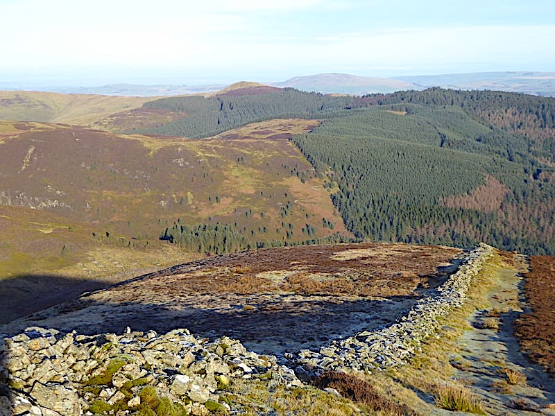
….. the cairn marking Hobcarton End, not that you need anything to mark it because, as you can see from the previous shot, its fairly obvious that you’ve reached the end of it, there being nothing between it and a long drop down into Whinlatter Pass. The long ridge rising up Grisedale Pike was part of our outward route, there is a lot more of it but its hidden below the flat area around Hobcarton End.

From Hobcarton End the path becomes narrower and rougher as it makes its winding way down through the heather towards Black Crag. The long shadow of Grisedale Pike is just missing the top of the crag and it catches a splash of sun as a result.

From the descent of Black Crag we peep down into the very frosty Whinlatter Pass as it makes it way between Braithwaite and Lorton Vale …..

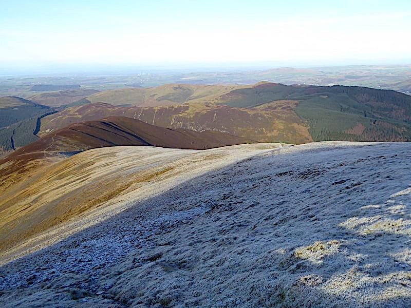
….. and then take a look behind us at Grisedale Pike and the source of Grisedale Gill. Over on the left is the level ridge of Kinn and, if you zoom in, just below that you may be able to pick out the light coloured line of the broken wall which we walked up beside on the outward leg of our climb. Its a very long and steep climb, and the very bottom part of the route appears in the next shot …..

….. over on the right, its the light coloured line which can be seen just above the trees and is the start of the long climb up. We reached it via the track from the marker post which was situated just about where the forestry track disappears behind the stand of trees beside Grisedale Gill. J is picking his way carefully down the narrow path lined with knee high heather, my knee height that is, not his.

The Vale of Keswick ahead as we continue our descent towards the felled area of forest on the right …..

….. where the path remains clear despite the surrounding mess of tree stumps and assorted brash …..

….. and leads us on into the darkness of the forest although it doesn’t look quite as dark as it really was as the camera has compensated for the lack of light to a large extent.

The track eventually turns from muddy to a surfaced road which forestry vehicles can easily use and we turn our steps towards the car park. The road that J is on is the more direct one for Grisedale Pike from the car park which I mentioned earlier. At this junction, if you were heading for Grisedale Pike, you would not turn up the road on the left of the shot or you’d end up going up over Hobcarton. Instead you would simply carry straight on behind me and the road would eventually lead you to the crossing over Sanderson Gill where you would bear left and up the track to the Grisedale waymark post. From here its about a ten minute walk back to …..

….. the gate across the lower path from the car park. All we have to do now is go through it, turn up to the right and walk the last few paces back to the car. A couple of forestry workers were repositioning one of the wooden marker poles to the vertical and cementing it in and who gave us a nod before carrying on with what they were doing. There’s one other car in the car park but no sign of its occupants and, with the exception of the few folk up on the summit, we’ve met no-one at all on the outward or return legs of our walk. We’ve had a grand walk today, not a very long one but the steepness of it more than made up for the lack of miles, and we had some proper cold and frosty winter weather to enjoy it in. You have probably noticed the total absence of snow anywhere even though we are well into winter now. There was a brief flurry on 21st November last year which gave Helvellyn and many of the higher tops a brief dusting but then the weather turned mild and rainy again so it disappeared almost as quickly as it came. There’s still enough winter left for a decent fall though but we’ll just have to wait and see.