
Hardendale and Oddendale
Walk date – 13th July 2023
Distance – 5.1 miles
Weather – fair weather cloud, sunny spells, very windy
In complete contrast to the forecast today’s weather brought an unexpected break up of the blanket of cloud which has persisted day after day just lately and by lunch time the sunny spells were becoming more prolonged and looked set to continue. It was still very windy though so we decided to have a short walk quite close to home on some of the lesser hills to the east of Shap. There are limestone pavements in abundance here so there’s plenty of evidence of quarrying together with a large amount of ancient cairns, curricks and stone circles indicating the presence of human activity but whose history is now forever lost in the mists of time.
Route
Hardendale Lane – Hardendale Nab – Hardendale Quarry – Iron Hill – Harberwain Rigg – Oddendale – Seal Howe – Hardendale Quarry – Hardendale Lane


We parked off road beside the lane up to the hamlet of Hardendale from where we have a good view across to High Street, Kidsty Pike and High Raise. I had to hang on to the car door as I opened it to prevent the strong wind yanking it off its hinges, so what it must be like over there on High Street heaven only knows.

A local resident gives me the once over as I take this shot looking eastward towards Cross Fell on the nothern Pennines. In the trees just ahead is the hamlet of Hardendale and that’s where the tarmac lane ends. From here we climb just a very short distance up to …..

….. the curricks just below the top of Hardendale Nab. We came up here a few days ago on a much murkier day so I didn’t have the camera with me and on that occasion there were six curricks. The sixth one has since collapsed and its stones are in a heap just out of shot to the left. We did think at the time that it had been built at a later time than the five in the shot and it wasn’t as well constructed. I don’t think it has been pushed over deliberately, at least I hope no-one has done such a thing, I think its more likely that a sheep has scratched itself against it and accidentally knocked it over. If that’s the case the sheep must have had quite a fright. Just how long these curricks have been standing here I have no idea but judging by the amount of lichen and algae growing on them it must be a considerable amount of time, those things are not exactly famous for their rapid growth rates.
Just a very short distance from the curricks is the top of Hardendale Nab, a limestone pavement the length of which is now grass covered.

The view back to the curricks indicates just how short the distance is between the two. Some of the northern fells are just visible on the right of the skyline. Blencathra is visible but it will need a zoom in to identify it.

The Howgills form the southern skyline as we walk along the top of Hardendale Nab, the limestone cliffs on this side create quite a drop.

Below us is the M6 …..

….. and looking directly west into Wet Sleddale and its reservoir. The Tata company’s limestone works were an unavoidable intrusion. I had trouble keeping my balance taking this shot as the strong westerly wind was coming directly at me.

We left the windy conditions on the hill top and headed eastward towards the quarry. We had hoped that we’d gain some respite from the wind along here but we were still getting battered.

The cliffs of the quarry begin to appear …..

….. and are quickly followed by the appearance of the quarry pool …..

….. so we made our way down to the fence for a better view.

Information board in front of the fence …..

….. and a close up of some of the information. Its quite a long board so its difficult to show all the information.

We continue down towards the fence line where a gate allows us to gain access to the path going down the hill at the northern end of the quarry. Our route will take us down the hill to the tarmac lane by the tree plantation. When the lane reaches the first single tree we will leave it, pass through a gate close to the tree and continue on through a lonning across to Iron Hill.

The quarry cliffs from the tarmac lane. The wind is just as strong down here as is indicated by the rough surface of the quarry water.

A look back at our route from Hardendale Nab from the tarmac lane.

The quarry pool is fenced off but the broken down wall offers the chance of at least getting a little closer …..

….. and getting a better view of the cliffs and the water. Note the blown over lifebelt stand.

Walking through the lonning where the tall grasses were being tossed every which way by the wind. Some of them were as tall as I am, although that’s not saying very much, but at least the lonning wasn’t full of bracken.

Looking back at the quarry as we walk through the lonning…..

….. and another view of High Street and its neighbours over to the right.

We’ve left the lonning behind now and continue across the open fields towards Iron Hill.

The stone circle on Iron Hill is the first thing we come across, despite the map indicating otherwise, and in the distance is the cairn itself.

Looking west back to the quarry from the stone circle.

We stroll across Iron Hill to the ancient cairn …..

….. with J’s hair (and mine) plastered down by the wind. We almost didn’t bother with walking poles today so we only took one each. I gave mine to J while I took a photo and it looks as if its being put to good use. Cross Fell is back in view.

The distant skyline showing Mallerstang Edge (L) and Wild Boar Fell (R).

On we go making our way over to Oddendale with a pleasant green path under our feet all the way. Oddendale hamlet is in the patch of trees in the centre of the shot. Behind the patch of trees is what we call Hill 401 as it doesn’t appear to have a name. We often have a walk over there but I’ve never taken the camera with me, perhaps I should next time we go there.

We reach Oddendale and its tiny hamlet of houses encircled with trees …..

….. and the lane entrance to the little hamlet. The houses are well protected from strong winds by the surrounding trees, so well protected that its impossible to see anything other than the entrance.

From the hamlet we follow a gravel farm track and make our way over to Seal Howe. A patch of limestone pavement comes into view just a short distance away so I stopped to take a look back from it towards Hardendale Nab.

Approaching the cairn on Seal Howe ……

….. the other side of which reveals a partial collapse. How long it has been here is unknown. Over to the right of the shot is another stone structure which we eventually went over to take a look at.

Hardendale Nab and the quarry from the cairn on Seal Howe.

We’re now at the stone structure I’ve just mentioned but I’ve no idea what its original purpose was. It is a very long curved oval shape and the two end sections are not joined on to anything. As the tallest section of it has its back to the west, the prevailing wind direction, perhaps it served as a shelter for whatever animals were being kept by those ancient hill dwellers.

As we returned from Seal Howe we came across another very similar structure, built to the same pattern and similarly located against the prevailing winds. Had we known of its existence we would have searched for the double stone circle which is also located on Seal Howe, on another visit we’ll go and look for it.

Back at the southern end of the quarry now and its abundance of notices effectively telling everyone to keep out – Danger/Keep out/Quarry/Deep water/Do not swim/Cold water can kill/Cliff edges/Quicksand. Why not include crocodiles and man-eating sharks while you’re about it?

The piles of shingle indicate the edge of the high wall of cliffs below which are the spoil heaps left over from the quarrying.

The view towards the northern end of the quarry from the southern end, between the two is this vast area of lunar like wilderness beyond which is the deep quarry pool.

Hardendale Nab over to the left with the quarry cliffs below it.

Hardendale Nab again as we reach the end of the quarrying area. From here we go down the steps and make our way around the lower end of the hill to reach the lane leading up to Hardendale hamlet.

Walking back to the Hardendale lane now along the main quarry road where a much smaller quarry pool is situated. Another limestone pavement is visible along the crest of the distant hill.

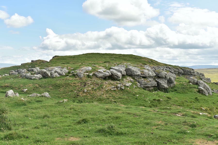
Walking back up the little tarmac lane leading to Hardendale hamlet with the limestone escarpments of Hardendale Nab ahead of us. It doesn’t take very much longer before …..

….. we are back where we started. The handful of cars which were parked when we arrived have gone and they probably belonged to local residents who were out walking their dogs as its a popular place for that activity. These lesser hills eventually tail off and become the flatter lands of the Eden Valley beyond which the land begins to rise again and eventually becomes the North Pennines which can be seen in the distance. We met only two people just as we were about to enter the lonning, so if peace and quiet is what you require this could be the place for you, and its a lovely area to walk in on a day such as today. On completing our walk report I looked out of the window to find that the weather has reverted to type – its raining and the tree branches are being blown horizontal.