
High Cup Nick
Walk Date – 13th August 2017
Distance – 7.4 miles
Weather – sunny morning, cloudier afternoon, dry
Today’s walk takes us up to a hidden gem and one of England’s most spectacular geological features, the classic U-shaped glaciated valley of High Cup Nick. It is carved deep into the western side of the Cumbrian Pennines and shielded from casual view by a series of small hills. There are several ways to approach it and our route today was from the western side close to Dufton village. Our route was a straightforward out and back, for reasons which will become obvious later, but it is possible to make this a circular walk by dropping down into High Cup Gill and returning to the start point from Harbour Flatt. Alternatively you could return along the top of eastern rim of the Nick and drop back down to Murton, taking in Murton Pike on the way if you felt like it.
Route – out and back
Bow Hall, Dufton – Pennine Way – Peeping Hill – Narrow Gate – High Cup Nick – Narrow Gate – Peeping Hill – Bow Hall, Dufton


There is a free car park in Dufton village but starting from the village involves a three quarters of a mile road walk, to get to this point, just beyond Bow Hall, where the tarmac road ends. Road walking can become tedious after a while so we opted to start from here. There is room along the road side for about half a dozen cars but there was only one already there when we arrived just before 10.00 am. The distance given on the post is a little misleading as it indicates that it is 2.75 miles up to High Cup Nick. It is a little more than that though and after setting the gps at this point the distance was reading 3.70 miles by the time we reached the head of the valley.

The road side parking area is just off to the right so its only a couple of paces before we are heading off down the very watery track and on our way to High Cup Nick. Its a lovely morning, sunshine, soft white cloud and plenty of blue sky so it was t-shirt level right from the off.

We climb steadily and on our right a sturdy barn nestles below one of the lower hills, not named on our route map but indicated by the height of 388 metres. On the OS map it goes by the name of Gregory, another one of those unusual hill names that gets you musing on the reason why.

The track is quite rough and climbs steadily all the way. There is nothing ferociously steep so you are never quite gasping for breath, but as the rise is continuous all the way it definitely gets the lungs and heart pumping. Here I’m looking back down the track and across the Eden Valley to the Lake District fells.

Ahead of us a group of four walkers maintaining their steady pace along this undulating section of the track. The heather coming into bloom in the fields below Peeping Hill.

A look back to Dufton Pike and the Eden valley as we pass through the kissing gate. At the moment its just us and the group of four ahead of us who are making their way up to High Cup Nick.

We arrive at a long disused limestone quarry where the large notice asks us to use the stile rather than the gate, which we do because its often easier than struggling with an unyielding gate latch. Immediately above the smaller notice and just below the skyline you might be able to pick out a dark arch shape by the rocks up there. This is an old lime kiln. The group of four walkers had stopped close to this point and they were spread out on the grass with the coffee flasks and biscuits out. I could have done with a coffee at this point but had to make do with a swig of orange juice, which deals with the thirst but isn’t quite as satisfactory somehow.

Once over the stile we go straight ahead and into the disused quarry area where there is a choice of paths, all of which join up with another one just below the skyline. We chose a path bearing to the right which took us away from the lime kiln so I don’t have a closer shot of it than the one in the photo.

Up on the main track again where all the various quarry paths converge and a shot of how the quarry looks from the top. Apart from the out of place grassy lumps and bumps of the one time spoil heaps and the old lime kiln there is little to indicate now that this was once a place of industry.

From the top of the quarry we turn around and see that there is more hill climbing still to be done. Plenty of cairns mark the way but the path is so well trodden that it would be difficult to lose. Unless of course the fog was so thick that all you could see were the toe ends of your boots.
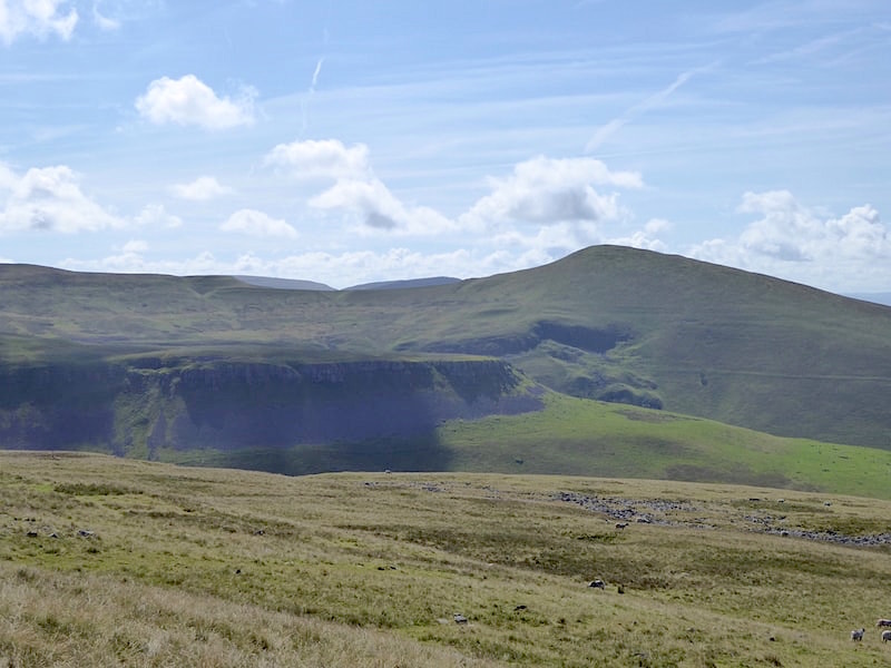
Eventually we reach some marginally more level ground and have a view of Murton Pike with the flat rim of Middle Tongue and its crags below it. Middle Tongue is the south western end of High Cup Nick and between us and it is High Cup Gill so we are getting closer to our destination.

From the cairn and over to the right you get a hint of what is to come but all is not yet revealed …..

….. and you still have plenty more climbing to do before the ‘big reveal’.

Once you have scaled the incline you do get a section of relatively level walking for a while. The group of four have finished their coffee break and as I took this look back I could just see them cresting the rise at the end of the path.

Eventually the point is reached where you begin to see a little more of High Cup Nick …..

….. but the path leads you away and a series of outcrops and the crests of contours continue to obstruct the view. The arrow on the marker post indicating that you should keep to the left, although by now its blindingly obvious that should you wander over to the right a drop of several hundred feet awaits you.

Still following the track along the flanks of Beckstone Edge, which is littered with rocks and boulders, beyond which we can still only see the eastern rim of the Nick.

Finally we walk clear of all the obstructions and out onto the flat grassy area of High Cup Plain where we get the first uninterrupted view of the tremendous gash, and the jaw-dropping view, of High Cup Nick.

The path now stretches out in front of us over closely cropped grass, courtesy of the numerous sheep all around us, and we make our way over to High Cup Nick Head.

Along the way there are numerous gullies to peer down where rock columns such as this can be seen.

A close up of the rock column, which seemed to me to be brother chip to the Eskdale Needle. The column, marked on the OS map but not on my route map, is known as Nichol’s Chair. Apparently Mr Nichol, a local cobbler from Dufton, is said to have climbed the pinnacle and then soled and heeled a pair of boots while he was up there. Now why anyone would decide to do that? A challenge thrown down during a boozy night in the Stag Inn perhaps?

Nearing the head of High Cup Nick and immediately opposite is the reason we didn’t choose to return via the valley route. The descent to the valley floor involves dropping down from the rim via this steep boulder field. Boulder fields are usually manageable with care but the at the moment we still have a recuperating foot to consider, which still isn’t at all happy with a steep descent, especially over an uneven surface. As that’s a very steep descent with a very, very uneven layer of boulders across it we decided that the sensible thing to do was not to take the risk until the foot is completely recovered. Its improving gradually but we’ll wait until it can cope without any niggles, aches or pains whatsoever, only then will we know that the recovery is complete.

More gullies to peer down as we round the head of High Cup Nick. One of the many striking features of the Nick is the sheet of rock just below the rim on both sides of the valley. This rock sheet is known as the Great Whin Sill, up to 260 feet thick in places, which was formed around 295 million years ago when molten rock was thrust up towards the surface from deep within the earth. The molten rock spread out between the existing layers of bedrock where it cooled and solidified. As it cooled the rock contracted into many vertical cracks forming those distinctive rough columns. The Great Whin Sill lies below much of north east England and another major outcrop can be seen at High Force in Teesdale which we took a walk to earlier this year on 26th March.

From High Cup Nick Head the view along this spectacular glacial valley where the Great Whin Sill can be clearly seen along both sides of the rim.

A couple of small becks flow towards the rim and we followed this one a few yards back to its source on the plain where it simply appeared as a thin runnel from a hole in the ground. It gradually widened and made its way over to the edge of the plain and dribbled down over the rocks before eventually disappearing back into them again.

We made our way across to the eastern rim with a view of another possible descent gully over to the left

This gully also has a small stream flowing down it and that too eventually disappears beneath the gully rocks and boulder field further down. On the skyline opposite is Beckstone Edge.

Further along the eastern rim and a view of the beck in the previous shot flowing down into the gully. The small grassy area on the left hand bank was a grand little sun trap, out of the coolish breeze which had greeted us once we were up on the plain, so we had a lunch stop there. We had our jackets on by now since the breeze and some large cloud cover from time to time kept the temperature pegged back.

Another gully, this time dry, as we wandered a little further along the south eastern rim to take a look at the north western side below Beckstone Edge.

I know it looks empty but there were plenty of walkers up here today, most of whom had found sheltered places from which to enjoy the view, leaving only that very hardy pair, seen as a white dot perched above the rim, eating their sandwiches and getting the full blast of the breeze rushing up from the valley.

We begin to make our way back to the head of the valley all the while watching the large cloud shadows morphing into a multitude of shapes and patterns as they drifted across it.

Another peep down one of the many steep gullies.

Heading back towards the head of the valley and the darkish patch in the rim, just off centre, is where the first stream begins to dribble over the edge. It manages to dampen the higher rocks and the surrounding grass but we could see nothing of it below that. It just seems to disappear into the boulders.

Back at the second stream which also has plenty of water flowing into the gully …..

….. but it too eventually disappears into the jumble of rock.

As far as we could tell the water appears again quite a long way down the valley, and is added to by numerous becks flowing into it from both sides of the valley.

Another look at the Great Whin Sill columns as we cross the head of the valley …..

….. and a view of some fragile looking columns as we reach the other side. Give it another few years of winter weather and this view might look rather different then.

We are well on our way back along the north western edge now and walking slightly closer to the edge than we did on the outward leg. This is quite a narrow path compared with the one higher up behind me and a good place for view along High Cup Gill and over to Murton Pike. You may have noticed from a few of the photos that the in colour for sheep marking this year seems to be blue, whereas last year I seem to remember the predominant colour being a pinky red.

A view of the track, with a pair of walkers, on the flanks of Beckstone Edge. We still have a sunny patch but the cloud is building and the Eden Valley and Lake District side are looking quite grey from up here.

A look back at High Cup Nick before we lose the view. The path, known as Narrow Gate, is quite thin along here and runs just below the point on the route map marked Narrowgate Beacon. I was too busy keeping an eye on the path to be looking out for a beacon which was a couple of hundred feet above me so I wasn’t likely to see it from down here anyway.

Continuing along the Narrow Gate path and back to the view of Middle Tongue Crags at the end of High Cup NIck.

A view of both of the paths we used today from below Hannah’s Well, a spring which rises a little higher up behind me. In turn the stream becomes known as Strands Beck and there it goes over the edge on its way down to High Cup Gill. The paved path you can see crossing the beck is the one we used on the outward leg and above it, as you look at the photo, is a groove between two grassy mounds. That’s the Narrow Gate path and the one we used on the return leg.

We may have left the dramatic scenery behind but there’s still a lot of the high level valley route to be walked before we bear right and follow the path back to Dufton. We hung back a little just to give those two guys a bit of room but they were walking so slowly that we just had to go past them. A pleasant couple of chaps who exchanged a few words with us as we approached and went by them.

Back at the cairn on the sort of level bit and here we bear right and head downhill all the way back to the car. Its only 1.45 pm and now we were meeting more and more walkers making their way up and having a Sunday afternoon walk. Despite looking deceptively flat the path is relentlessly uphill and everyone we met was breathing heavily.

Back to the old limestone quarry and heading for the stile in the wall over there.

Well on our way down now and a view of Dufton Pike and Knock Pike as we pass below Peeping Hill.

Patriotic sheep markings?

Back at the parking area with room for one more to squeeze in. On the same side but over my right shoulder a couple more vehicles were parked. One of them was an ancient camper van whose owner was trying to turn it round so he could drive nose first between the gateposts and onto the tarmac. The van was ancient enough not to have power steering, and the driver was elderly enough to be struggling because of the lack of it. The gears were grinding, the engine revving, with exhaust fumes pouring out as he inched his way forwards and back, forwards and back, to complete the 180 degree turn. It seemed as though it was going to take the same number of turn points to get there as well so J eventually stepped in and gave him some guidance, I don’t think he was able to put up with any more of the mayhem and confusion. Anyway the thing got turned round and they were able to get on their way with no more messing around. By now the cloud cover had built up and the sunshine had gone so we’ve had the best of the day it would seem. Shall we go home and have a cup of tea? Aye, why not?