
Brock Crags and Angletarn PIkes
Walk Date – 11th February 2019
Distance – 7.4 miles
Weather – dry, sunny and mild, breezy
The stormy winds and driving rain of the last few days have gone to wreak their havoc somewhere else and today we had a much calmer and drier day for our walk. We generally like to do this walk when snow is on the ground but it hasn’t stayed around long enough at lower levels this winter, but even so a walk up to Angle Tarn is always something to look forward to because its a little gem of a tarn in a lovely setting.
Route
Hartsop – Brock Crags – Buck Crag – Angle Tarn – Angletarn Pikes – Boredale Hause – Hartsop

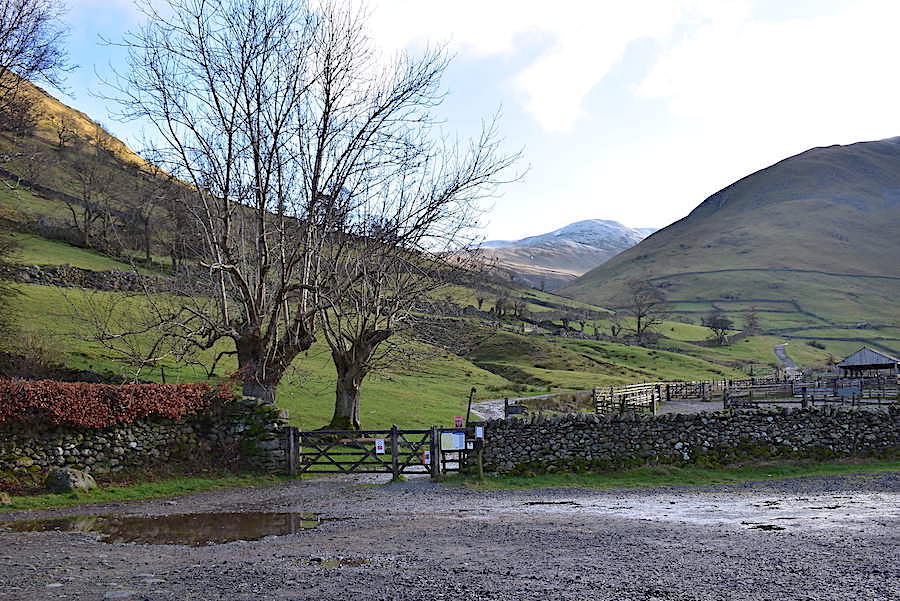
An empty car park awaited us as we arrived in Hartsop village which is something of a first for us because there’s always been two or three cars already parked when we’ve arrived on previous occasions. It didn’t last long though and by the time we were kitted up and going through the gate another car came dashing in, leaving me wondering yet again why folks are always in so much of a rush these days. As usual, because there’s no charge for parking, we made a donation to the village funds and popped some money into the box on the post by the gate.

We leave the car’s occupants to their kitting up and set off up the track above Hayeswater Gill. I took a look back at the stock pens just after passing them, it was much too bright a morning to take a shot as we approached them.

At the cattle grid we take the left hand path which will lead us over to the old filter house. The path going off to the right drops down to the bridge across the gill and then begins rising again as it traverses the slopes of Gray Crag and eventually leads up to Hayeswater.

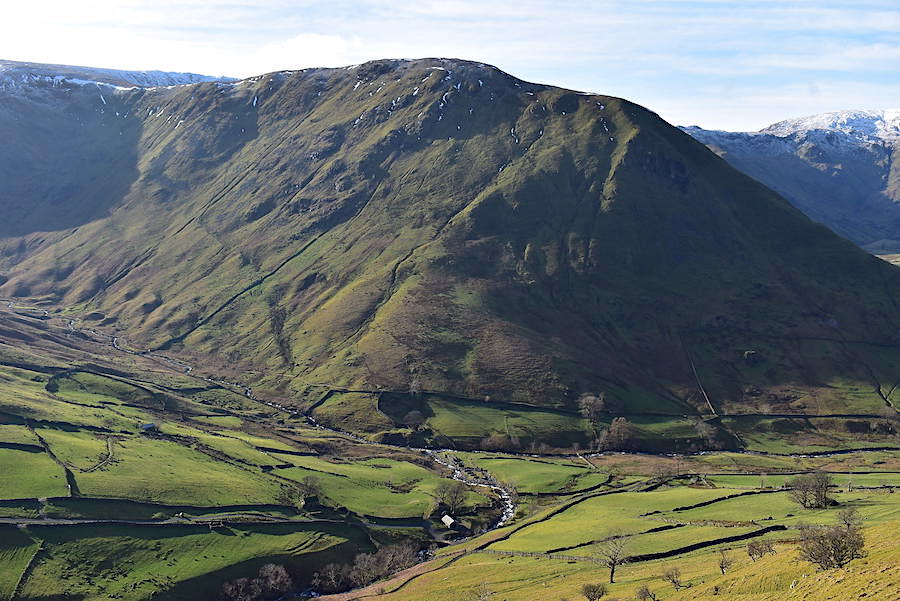
Below is the afore-mentioned bridge and, beside the bridge, the powerhouse building which houses the generator and turbine for the Hayeswater micro hydro which began supplying electricity to the National Grid in 2016. Behind it all is the massive bulk of Gray Crag. That’s a steep climb whichever route is chosen.

We reach the old filter house from where I took a look back along the valley to where Hartsop above How, across the centre of the shot, brings the view to a full stop, more or less. Hayeswater Gill is in the bottom left of the shot and on the path we have a gill of our own as water pours off the fellsides and takes the easiest way down the slopes. Its not so easy walking up though and its quite a stiffish pull up for most of its length.

We had a wander up to the old filter house before doubling back onto the grassy path across the lower slopes of Brock Crags. As its name implies, the water from Hayeswater was filtered in this building in the days when Hayeswater was used as a reservoir. That use came to an end in 2005.

Hartsop Dodd in the centre and the path to the filter house at the bottom of the shot. The filter house is now behind us as we’ve doubled back …..

….. to follow the grass path across the lower slopes of Brock Crags with a view of a snowy Saint Sunday Crag ahead of us. We’re in full sun now and, although the gradient isn’t severe, our body heat begins to rise as we traverse the steady incline.

A closer look at the snowy tops of Dove Crag, Hart Crag and Fairfield on the skyline …..

….. an even closer look at Saint Sunday Crag …..

….. followed by a long zoom over to Fairfield and Cofa Pike which still have a good covering of snow.

Just before we leave the grass track to head uphill my jacket and gloves just have to come off. The sun is strong, there’s no wind at the moment so the air is warm, my t-shirt is stuck to my skin and my face is wet with perspiration. The stop gave me the chance to have another play with the zoom for this shot of the former Myers Head Lead Mine beside Hayeswater Gill.

This longer view though shows how far below us the old mine really was and if you zoom in you can find it located just beside the gill towards the bottom of the shot. The roof of the recently built powerhouse is glinting in the sunlight to the left of it. One hundred and fifty years or so may be separating the two structures, but their respective uses of water power still connects them. The two figures heading towards us at the bottom left of the shot were the occupants of the second car which arrived in the car park just as we were starting out, and at the bottom centre of the shot you may be able to pick out another two. We had noticed all four come to a halt at the very spot where we had turned off the path, take a look around and then begin heading up towards us. There’s no need to leave the path down there, it just happens to be something we do. It brings us up to the next level of the path and eliminates the extra yards of walking needed to reach the actual turn off point. It seemed as if we were being followed and that the closest pair were keen to get ahead of us.

The pair came by us as I stopped to take this shot of a cloud passing over The Knott and …..

….. below us the two ladies have also stopped for a rest. It may not look very steep but it is a stiff climb and with the sun so strong and shining directly on us it made for some very warm work.
We plod on until another face mopping stop is required and so out comes the camera for a shot of the very steep slopes of Hartsop Dodd.
The view ahead as we continue up the stiff climb. I had to wait a few minutes for the pair ahead of us to disappear over the brow. The steepness has slowed them down too and it took a while for them to reach it. Having done so I thought they would just disappear over it but no, they had another stop for a couple of minutes just at the top before continuing. I was glad of the enforced stop though because things were now beginning to ache a little on the right side of my back and although its not quite the same problem as I had last year, its in roughly the same area. Its not only confined to walking uphill either, I have the same problem after I’ve been swimming, so there’s something about the lower right side of my back which isn’t happy when asked to put some effort in.

Typically and true to form, after crossing Calfgate Gill and reaching the line of old fence posts across the flatter ground, a large cloud passes in front of the sun and kills the light, plunging us and …..
….. everything else into temporary shade, although the top of Rest Dodd, behind Satura Crag, still has some sunlight.

From the gap in the wall a look back towards Gray Crag and a little smidge of Hayeswater. There is a lot of cloud to the south, beyond High Steet and Caudale Moor, and its the reason why we are plunged into shadow from time to time.

Above us we have nothing more than a few cloudy wisps drifting across the blue sky as we turn up to follow the path over to Brock Crags.

Angle Tarn, Angletarn Pikes and Place Fell come into view as we cross over.

The route across the moist and undulating top of Brock Crags …..

….. with the summit in view as we skirt around the wet bits. As we were crossing over the pair who had passed by us on the slopes of Brock Crags came towards us having just left the summit. One of them cheerfully informed us that there was ‘not far to go now’. Well thanks for that love, we’ve only been up to Brock Crags nine times so we had no idea how far we had to go. However well such a remark is intended it is often based on an assumption and if that assumption is incorrect then the recipients will feel irritated, and rightly so. It is better to say nothing than risk offence.

From one of the many pools along the way a look across to Arthur’s Pike, Bonscale Pike and Loadpot Hill over on the right. Beda Fell and Steel Knotts are just peeping up across the middle. A solo walker came towards us around this point and remarked that he’d never known it so busy up here. It wasn’t at all crowded but we knew what he meant.
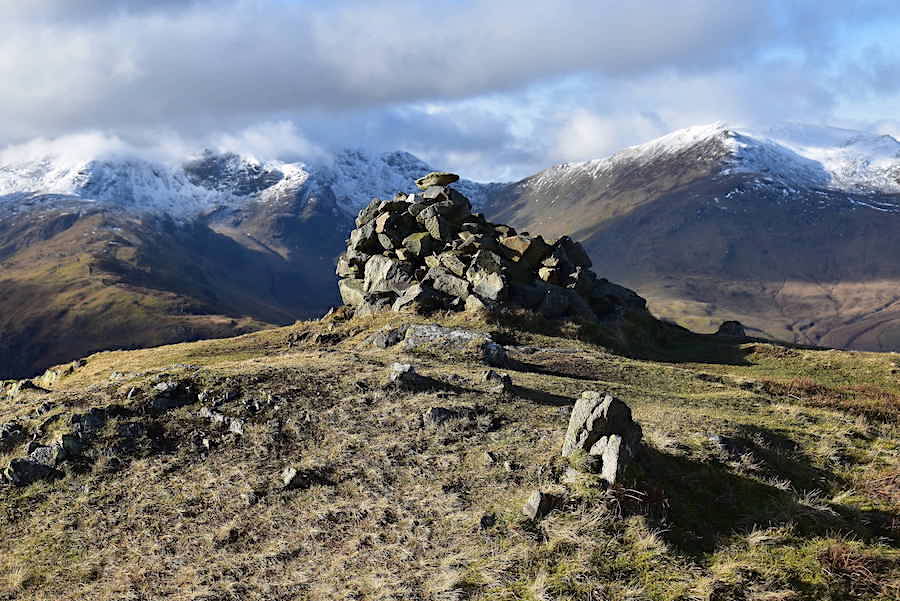
The summit cairn on Brock Crags where I put my jacket back on, now that we have a lively breeze, and where we decided to take a coffee break after which I wandered around taking a few shots of the surrounding views …..

….. zooming in on Gray Crag behind which the cloud is obliterating the tops of High Street and Thornthwaite Crag …..

….. another zoom to take a closer look over to Rest Dodd …..

….. followed by another zoom in on The Knott.

Looking to the west now to where thick cloud is enveloping Hart Crag and Fairfield …..
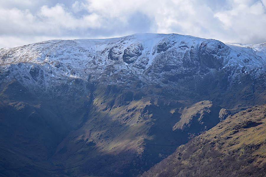
….. while Dove Crag remains in the clear. A zoom in to the bulbous and snow sprinkled lump of rock on the right of it will show the location of The Priest’s Hole.

Beyond Birks a view of the length of the Striding Edge route, from the ‘Hole in the Wall’, next to the wall on the right, to the rock tower known as ‘The Chimney’, on the left, up to Helvellyn, although the summit of Helvellyn is covered by cloud. Behind Striding Edge is Catstycam, which looks to have had another fall of snow since we were on Sheffield Pike last week.

Beyond Birkhouse Moor, Raise also looks snowier than it did last week with the dark stones of the collapsed flue up to the chimney showing up clearly against the whiteness.

More cloud cover casting light and shade over Angletarn Pikes and Place Fell.

Looking to the northwest with the heathery slopes of Sheffield Pike and Glenridding Dodd below us. Brown Hills, with Hart Side behind it, to their right, and Stybarrow Dodd just peeping out of the top left hand corner.

Dramatic goings-on to the south with cloud boiling over High Street as I look towards Gray Crag and Hayeswater again.

A sunnier view of the summit cairn on Brock Crags.
Brothers Water far below us in Patterdale.

I drop down a short distance from the summit for a better view of Angle Tarn. Its normally busy with walkers but there were none around today.

While I’ve been busy taking the previous shots the two ladies who were following behind us have had time to join J on the summit, have their coffee break, pack up their gear again and were just leaving the cairn as I returned to it. They headed off northwards directly down to the tarn as I returned to the summit. We decided that we’ll retrace our steps across the boggy area and carry on down to the tarn using the Satura Crags path.

Looking to the west beyond Brock Crags, as we retrace our steps, and in ascending order we can see Arnison Crag and Birks in the middle foreground, above them is the Striding Edge route and Birkhouse Moor. The Fairfield group and Helvellyn on the left skyline are still smothered by cloud while on the centre skyline Catstycam, White Side and Raise remain clear.

On the Satura Crag path now and a look over to the northwest. Raise is now on the left skyline followed by Stybarrow Dodd, Green Side, Great Dodd and Brown Hills. The path splits a little further on with the left side dropping lower towards the tarn, we keep to the higher one on the right to …..

….. arrive at Buck Crag with its extensive view along the length of Bannerdale …..

….. and a view of The Nab and its notorious peat hags …..

….. and the view of Rest Dodd peeping up above Bannerdale Head.
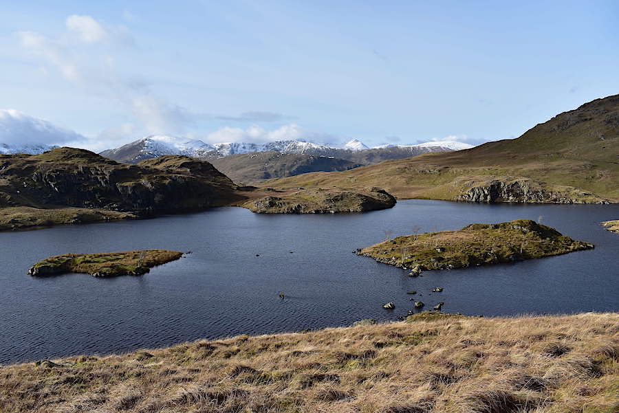
We drop down off Buck Crag and make our way to Angle Tarn where there isn’t a soul around and all is quiet and peaceful. The breeze isn’t so lively down here so we have a sunny lunch break and just let the world roll on by for a while. If this had been a fine day in August we wouldn’t have got a look in.

Still large banks of cloud over to the south and it seems as though the combined masses of High Street and the Fairfield group are preventing them from coming any further north. We don’t mind that one little bit because we’d prefer to hang on to our lovely little blue sky day for as long as possible. I just couldn’t resist another look back at Angle Tarn as we leave it behind and pick up the path round the lower slopes of …..

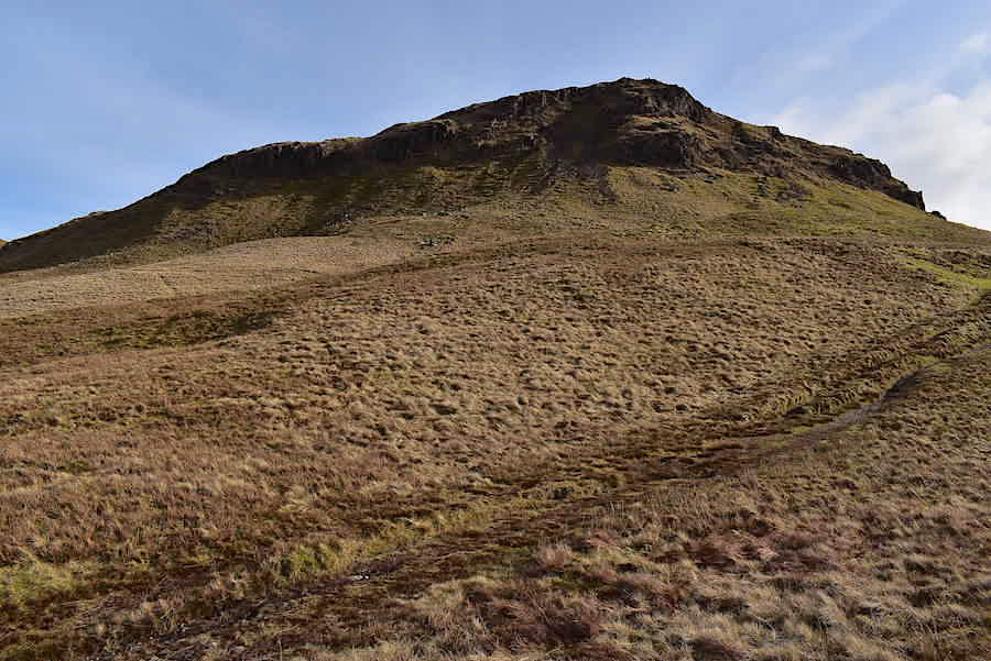
….. the south top of Angletarn Pikes. We leave the path at this point and head up towards the gap between the two outcrops. Its only a short climb, grassy and dry all the way up and not excessively steep either.

On our left as we climb up is the north top of Angletarn Pikes which we’ll cross over to eventually, although not by this route.
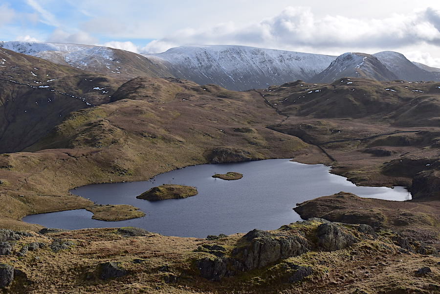
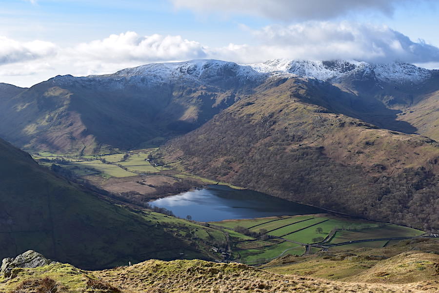
It doesn’t take very long to reach the south top from where you have a fabulous view of Angle Tarn in its magnificent setting. Even the sombre brown tones of winter cannot detract from the charm of it all. You may have gathered by now that this is my favourite tarn so I’m bound to be a little bit biased.

Zooming in across Bannerdale Head once again for another look over to Rest Dodd. Behind it we can now see High Raise, to the left, and Rampsgill Head, to the right.

J’s hair gets a make-over in the lively breeze on the south top of Angletarn Pikes. At least he can smile about it, or maybe he’s just noticed the scarecrow like state of my own hair and can’t help but laugh.

From the south top a look across to the north one with a shadowy Blencathra just peeping up behind it.

To get from one top to t’other we drop down and skirt around this boggy mush beyond which Beda Fell stretches away into the distance.

Round the boggy bit and heading towards the rocky ramparts of the north top from where …..

….. I take a look back at the south top noticing that the bank of cloud still cannot make it beyond High Street.

Looking north west from the north top towards Glenridding, Ullswater and Place Fell with Blencathra still in shade on the centre skyline. No sign of walkers anywhere below us.

The green fields of Pattedale below Arnison Crag, Birks and Saint Sunday Crag.
Time to be on the move again so we drop down from the north top and pick up the path back to Boredale Hause.

Empty paths everywhere as we make our way down to Boredale Hause.

Place Fell as we approach Boredale Hause. We did finally see four other walkers as we descended although they were over in the distance, on the right, making the crossing from Beda Fell and then dropping down into Boredale.

Boredale Hause is reached so we have a short break and take swigs of fruit juice to quench our thirsts. Its still very warm and sunny and will only get warmer as we lose height.

The lovely view towards the head of Ullswater and Glenridding from the Boredale Hause path.

Further down and we look directly into Deepdale across the swollen becks and rain soaked fields of Patterdale.

Brothers Water ahead, and above it the V shape of the Kirkstone Pass flanked by Caudale Moor and Red Screes.

In the valley bottom now and walking below the wooded slopes of Calf Close where this footbridge provides a crossing if the beck, which flows across the path, is in spate. The beck is little more than a shallow dribble today but I use the bridge anyway, because its there I suppose. J splashes through regardless.

The view up to the falls from the lower bridge. The footpath over the bridge in the shot also leads back to Hartsop village but we kept to the lower path for the flatter stroll back to Hartsop.

The western slopes of Gray Crag come alive in the bright afternoon sunlight. The walk along the lane back to Hartsop was directly into the sun and it was now very warm, at this point we were feeling like two steamed puddings. Removing jackets would involve downing packs and as there isn’t much further to go now we decided to sweat it out for the last half mile or so.

At the end of the lane we turn up the hill and walk towards the village. Across the fields Brock Crags are also bathed in sunlight.

Almost at the top of the hill is this very old house, complete with spinning gallery, and its so warm now that the occupants have their front door open. Just around the corner is the car park so we don’t have much further to go, and we’ll be relieved to get the packs off our backs and start to cool down a little. An ice-cream would have been more than welcome right now but we have to make do with finishing off the fruit juice and tucking into a tangerine each before setting off for home.