
Place Fell
Walk date – 2nd April 2021
Distance – 5.5 miles
Weather – dry and sunny, a nippy north-easterly breeze at height
A settled spell of sunny weather arrived, the garden dried out and was put back to rights, river and lake levels are dropping nicely, the spring flowers have burst into bloom and there are hints of green here and there as the first leaves on the trees begin to appear. There being no garden jobs left to do we went over to Patterdale and had a walk over Place Fell. More people were about today, as its Good Friday and a bank holiday, the car parks were not too busy when we arrived but when we drove back in the early afternoon everywhere was much busier. Good to see everyone out enjoying themselves in the good weather.
Route
Patterdale – Side Farm – Hare Shaw – Place Fell – Round How – Steel Edge – Boredale Hause – Side Farm – Patterdale


We parked at the Patterdale Cricket Club ground, set off along the road towards the George Starkey hut and from there turned along the track beside it and headed over to Side Farm. Further along the farm access track I took this view of Arnison Crag and Birks Fell from the bridge over Goldrill Beck.

At Side Farm we turned left and after about 100 yards passed through a metal gate where we had a decision to make, straight on from the gate would keep us on the track which runs alongside the wall. Turning right up the steep grassy bank would lead us to a higher path which runs more or less parallel to the one beside the wall. We turn to the right, scramble up the banking to reach the upper path and flatter ground where we pause to get our breath back while admiring the long distance views along Patterdale …..

….. while taking a closer look at Arnison Crag …..

….. and Birks Fell.

From the same spot a view into Grisedale towards the Helvellyn range, framed on the left by Birks and on the right by Birkhouse Moor. The little hill below Birkhouse Moor is Keldas, from where there are some lovely views along Ullswater despite its lowly height.

Further along there’s another view along a valley. Here we’re looking towards the Glenridding Beck valley above Glenridding. Raise is on the centre skyline framed by Birkhouse Moor on the left and Glenridding Dodd and Sheffield Pike on the right. Below us the lower path alongside the wall has come into view. Nobody walking along there at the moment but it will probably get busy later, its a very pleasant, and popular, walk over to Silver Crag and Silver Point.

A closer look at the Helvellyn group where just a few very small patches of snow are still hanging around. Not for much longer though if this sunny weather keeps up. Keldas, in the centre of the shot, stands at the head of Ullswater and the views from there are well worth the short walk up to the top of it. Lots of canoes out on the water today but only one sail boat.

Well, we’ve had a leisurely stroll along the upper path but at this point we branch off onto the path on the right. Its not quite such a leisurely stroll from this point onwards as its a stiffish climb up to Hare Shaw. That said, nothing difficult or awkward to negotiate will be encountered along the way and, as the path weaves its way through bushes and boulders, there are plenty of opportunities to sit for a minute or two to admire the views below while you get your breath back …..

….. and here on Hare Shaw are the views that are the reward for all the effort you’ve put in. Saint Sunday Crag is now visible above Birks Fell over to the left, Helvellyn and Catstycam are just showing behind Birkhouse Moor, with White Side and Raise over on the right. It was sunny and warm up here today so we stopped and had a coffee break. I was intending to take some more views afterwards but didn’t do once we had packed everything away again. Well, you know how things go, you’ve had a break and a chat, you put your gear away and set off again, and what you intended doing beforehand gets forgotten about.

A look back at our route from Hare Shaw as we head towards The Knight. The boggy section back there in the flattish area wasn’t too bad today which was a pleasant surprise.

A lone walker in residence on The Knight so we didn’t bother going over there. The large and excitable dog accompanying him was a flaming nuisance.

Just below the summit of Place Fell where the northern end of Ullswater and some of the far eastern fells come into view. The large tarn across the middle of the shot doesn’t have an official name so we just refer to it as Place Fell Tarn.

No-one around at the summit but we did notice a group coming up behind us so a quick shot before they arrived a few minutes later. Although not very strong the north-easterly breeze was quite chilly up here so another layer went on while we looked for a sheltered spot to take a break,

A hazy view to the south from the sheltered spot we settled on. The shelter down there wasn’t worth bothering with today as it was facing directly into the breeze.

Looking across Glenridding and on the skyline from left to right are White Side, Raise, Stybarrow Dodd and Great Dodd.

To the south-east where Rampsgill Head, High Street, Thornthwaite Crag and Ill Bell dominate the skyline.

On the southern skyline are Caudale Moor, St Raven’s Edge, Red Screes and Little Hart Crag. Below the latter are the ups and downs of the long, and the sometimes seemingly never-ending, ridge of Hartsop above How.
On the way down now with a ‘three for the price of one’ view of Arnison Crag, Birks Fell and Saint Sunday Crag. These three fells are often combined in one walk which covers about seven miles depending on the route chosen.

Looking towards Redgate Head from Round How. Today we followed the path below Redgate Head which avoids the scramble over the rocky gully. Just as well we did because when we reached it there was a group of four beginning to climb up it. Its a simple scramble but the two female members of the group were reluctant to attempt it despite the shouts of encouragement from the two males accompanying them who had already climbed it. The two girls managed it eventually but it took a while.

Looking along Steel Edge from Round How.

A look back towards the summit.

Re-joining the path after skirting around the rock gully section.

The path turns towards Beda Fell as it passes below Redgate Head. We’ve just passed a family group making their way up with one of the children wearily flopping down onto one of the stones. Mum said that they were nearly there, by way of encouragement I suppose, but in reality there was still some way to go for the tired youngster. I hope they got up to the summit in the end though. At the bend in the path just below us was a pair of walkers, also feeling the strain probably, who were taking a break from the long slog up. That’s really what this path is, a long and not very interesting slog up to the summit. Its OK for a straightforward route down but the ascent route we used is more varied and entertaining.

Heading down towards Boredale Hause with a view of the north top of Angletarn PIkes directly opposite.

A zoom in on Angletarn PIkes north top, Caudale Moor on the right skyline.

Boredale Hause comes into view.

The view of Arnison Crag, Birks Fell and Saint Sunday Crag from Boredale Hause. A brief stop at the Hause to remove a layer now we have left the nippy breeze behind.

Dropping down the Rooking path and heading back to Side Farm on a very warm and sunny afternoon.

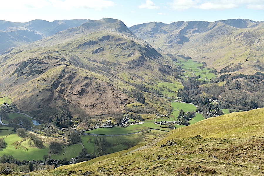
Place Fell in the sunshine as we drop down towards Rooking.

As we descended we came upon a group of lads, red-faced and sweating heavily, taking a break beside the path. They are hard to identify in the shot but a zoom in will help to locate them, sitting on either side of the path to the right of the trees. We had a chat when we reached them and learned that they were camping out overnight. They had enough gear to camp out for a week judging by the amount of bags they were carrying. In addition to their tents they were each hauling carrier bags of food, boxes of beer plus various odds and ends of clothing! No wonder sweat was pouring from their faces. When we asked where they were making for they replied ‘the first flat bit we get to’. The ‘first flat bit’ would be at the Hause so they still had a fair way to go before they reached anything remotely resembling flat. We were assured, even though neither of us mentioned it, that they had brought a roll of black plastic bags to take the rubbish away in.

There must have been about ten in the group altogether but they were spread out along the path in groups of two or three and each group we came to was taking a break and displaying various states of weariness. After we had left the tail end group behind we came across a large bag of wood, in a heavy duty plastic bag with carrying handles, lying beneath one of the nearby bushes, with what initially looked like a large grey football close beside it. From the printing on the side of it this turned out to be a sleeping bag and from its pristine appearance looked as if it had only just been bought. We wondered if these things belonged to the camping group to be picked up later but we’ll never know for sure. It was an interesting encounter with the lads but how they were going about things seemed to be a classic case of enthusiasm over experience. We left them struggling up the path and carried on down the path, made our way across the old quarry above Side Farm, down through the farm and back onto the farm access track.

From the farm track a look back across Rooking towards Angletarn Pikes before making our way back to the cricket ground and the car. All in all a most enjoyable day and it was good to see people back enjoying themselves even though everything is still shuttered and barred. We’re still bemused by the discarded bag of wood and the sleeping bag though.