
Rydal Water and Grasmere Circular
Walk date – 19th October 2022
Distance – 6.3 miles
Weather – Cloudy, occasional sunny spells, light breeze
There was an outside chance of a couple of hours of dry, calm weather to begin with this morning before the cloud cover returned. Strong winds were being forecast at height and the arduous walking conditions arising from them made a low level walk a better choice for us today. This circular walk is an old favourite of ours, a favourite which is shared by many others judging by the amount of people we saw doing just the same walk. Some were taking the clockwise direction as we did, while others opted for the anti-clockwise direction. We set out to do this walk last Thursday, an unexpectedly lovely sunny and wind free day, but could find absolutely nowhere to park as every possible parking area/space was taken and fully occupied so we put it on the pending list. On Tuesday of this week another similar day occurred, out of nowhere I might add, but as Tuesdays are already spoken for we were unable to take advantage of it. On the plus side the good weather day meant the washing could be drying outside on the line so it wasn’t entirely a non-productive day. The back problem continues to be a nuisance but today’s walk contained nothing to bother it and we spent a couple of very pleasant hours strolling through the various woodland and shoreline paths although by the time we were on our way back to Grasmere the cloud had rolled in and the weather window closed once again. Its not looking good for the next few days either and its raining (again) as I write.
Route
A591 Lay-by Grasmere – White Moss Common coffin route – Rydal Mount – Rydal Water – Grasmere Water – Grasmere – A591 Lay-by


Helm Crag from the lay-by which is just a couple of hundred yards from the roundabout on the outskirts of Grasmere village. The lay-by had a few cars already parked but we parked without difficulty today. As the photo shows there is a little light cloud about but by and large its a pleasant autumnal morning.
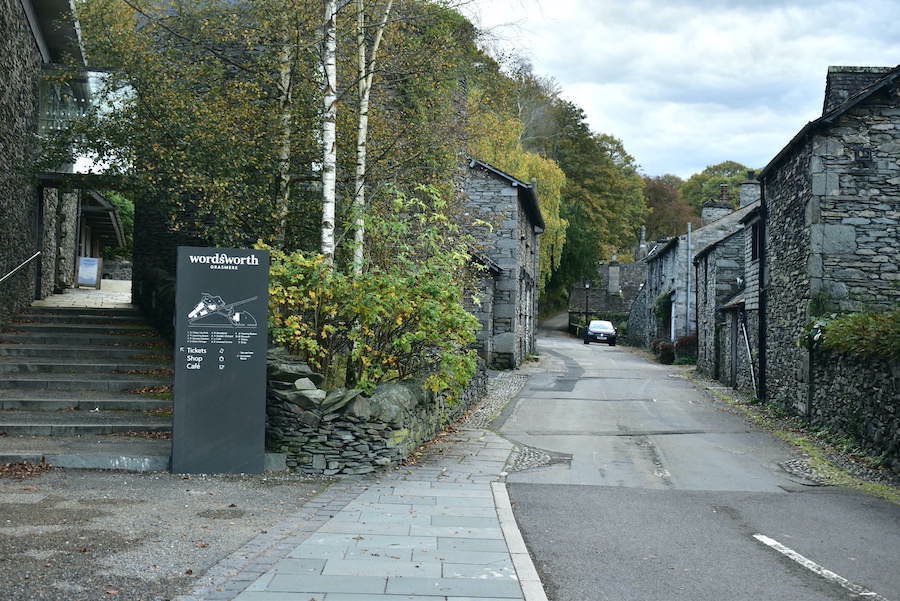
After walking from the lay-by down to the roundabout we turned up this little lane which takes us past the Wordsworth museum …..

….. and past Dove Cottage a little further on. The notice on the wall informs you that William Wordsworth and his sister Dorothy lived here from 1799 to 1808.

At the junction at the top of the hill you can take a breather, if you need one, courtesy of the metal bench on the left and enjoy the view. The path shown in the photo leads walkers through Brackenfell Wood and on up to Alcock Tarn with the option of continuing on up to Nab Scar, Heron Pike etc etc. I have my back to the path we took which leads us up to the old coffin route across White Moss Common and eventually to Rydal Mount.

At the top of the path from the junction the route levels out and in no time at all we arrive at the tarn with no name, it isn’t shown on our route map either although it is shown on OS maps as a long sliver of blue, though once again not named. Various names have been applied to it though, White Moss Tarn, Skater’s Tarn, Mr Wordsworth’s Tarn (apparently he used to skate on it) but nowadays if it does freeze over it would be difficult to do any skating at all as it is so overgrown and silted up. This was the only obvious area of water as the remainder was covered by the encroaching vegetation. What might be for the best – let nature take its course or not? I don’t know the answer to that.

A little further along the path is Dunney Beck, the path beside which is yet another route up to Alcock Tarn. A candidate for a future walk when the bracken has finally died back, perhaps this year will be when we finally get around to doing it, although we say that and then promptly forget all about it! Not the best shot I could have taken but then there was a large van belonging to the LDNP authority parked beside the fence so the viewing angle was somewhat limited. No sign of the park ranger though.

Loughrigg Fell and Rydal Water as we leave a woodland section behind and have a more open view. The bracken has finally turned completely brown on Loughrigg’s slopes but it is still only partial on the slopes below and above us on this side of the water.

Alien invader or dead tree? Its all down to one’s imagination.

The path eventually tips us out onto the hard surfaced lane at the top of Rydal Mount and as we strolled down the lane I took a few shots of some of the houses along the way …..

….. this is one of them which I’ve included as the intensely bright red leaves of the tree were absolutely stunning. I think its a Japanese Maple (Acer Palmatum) but don’t quote me on that as I didn’t go over and inspect the leaves, and there are other types of tree which turn bright red in autumn. We saw many of these in gardens today.

Towards the bottom of Rydal Mount is St Mary’s Church which apparently stands in the grounds of what was once an orchard. Mr Wordsworth was a churchwarden here from 1833 to 1834 and he didn’t have far to travel to perform his duties in that respect as he only lived just up the lane almost at the top of Rydal Mount.

The bottom of Rydal Mount is crossed by the A591 which we crossed and then turned right until we reached The Badger Bar above and just opposite it is …..

….. this pathway leading to the footbridge across the river Rothay and eventually to the shoreline path alongside Rydal Water.

Another muted sunny spell arrived as we crossed the bridge which illuminated the pastoral scene very nicely.

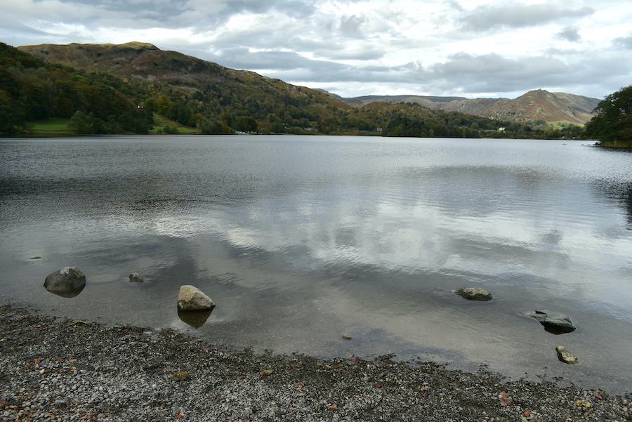
The path wends it way briefly through a wooded area so it isn’t long before you are out in the open again and Rydal Water makes its appearance.

The path runs very close to the water’s edge and just about every dog along the way made straight for it, plunged in, swam around for a while before running back out and shaking themselves vigorously all over their owners. I can’t speak for their owners but the dogs were thoroughly enjoying every minute of it.

Muted sunlight lands on Nab Scar across the water.

A look back at Rydal Water which will disappear from our view when we drop down from this high point and follow the path towards Grasmere water.

Silver How in the distance as we make our way down. We haven’t reached peak autumn yet as there is still quite a lot of greenery around. Another two or three weeks should do it though, always providing that any autumnal gales don’t strip off the leaves before they’ve had the chance to change into their lovely autumn colours.

Down at the weir now where things have turned a rather steely grey and everything becomes very muted. We’ve been aware of a very large blanket of cloud slowly approaching for some time and it looks as though the leading edge of it has arrived.
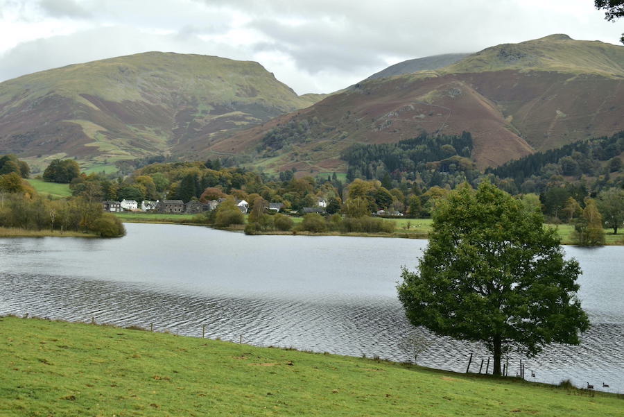
Grasmere in sombre mood. Still quite mild though and only a very light breeze ruffles the surface.

Dunmail Raise in the distance flanked by Seat Sandal on the right, and Helm Crag and Steel Fell on the left. The clouds are beginning to gang up above us.

I waited ages to take this shot. Having found a handy rock on which to perch we had stopped for a short break and I thought that this view of Silver Howe overlooking the water might turn out to be useful. No sooner had I got the camera out than a constant stream of walkers passed back and forth through the gate. Dogs splashed around in the water, folks took photos or just stopped to take in the view, you all know how it goes. I began to think it was hopeless and then, suddenly, there was no-one. The stillness returned and a small gull decided that things were quiet enough for it to perch on the fence post for a while. A quick click and Bob’s yer uncle.

Further along the shoreline path now looking towards Dunmail Raise again where we can see that the earlier brighter skies are disappearing as the cloud cover makes its way north.
The path moves further away from the shoreline which offers us a view of Seat Sandal (L) and Stone Arthur (R). Behind Stone Arthur is the darker mass of Fairfield. The ripples on the water show a slight increase in the strength of the breeze now. Around here (Dale End) some work is in progress, lots of machinery, materials and some fencing. From the notices attached to the fencing it seems that it is a ‘Boathouse Restoration Project’. The word ‘restoration’ I understand to mean to return something to its original condition but what we saw was nothing of the sort. The skeleton of a structure consisting of brand new steel supports (steel work supplied by a Cumbrian forge whose name was on a nearby notice and which I’ve forgotten) is not a ‘restoration’, it is a brand new building and, at the moment, looks nothing like what it is replacing. It is to be hoped that the exterior of this structure will be in keeping with its surroundings rather than the creation of an eyesore. End of rant!

Two grey ponies and their riders pass by as we walk down the road back to Grasmere village. J knows a good pony/horse when he sees one and thought that the leading one was especially good, hence the smile.

Here’s another ‘work in progress’, this time in the grounds of a hotel on the approach to the village. The hotel already has one such sculpture on the opposite side of its driveway, that one takes the form of an owl. (See our walk of 3rd June 2019 for a photo of that.) It will be interesting to see how this one turns out.

Grasmere was busy, as usual, so we didn’t linger once we reached it so here we are making our way back across the field path to the lay-by. Seat Sandal and Stone Arthur on the skyline …..

….. and on our left we have a view of Helm Crag and Steel Fell. We didn’t have much further to go from here so, with the cloud cover just about complete and the threat of rain in the air, we made our way back to the lay-by which was now completely full. The rain held off until about tea-time and then it tipped it down so with a bit of luck maybe the occupants of those cars made it back without getting a soaking.