
Sallows and Sour Howes from Moor Howe
Walk date – 13th August 2020
Distance – 8.3 miles
Weather – hot, light easterly breeze, very hazy
It is only five months since our last visit to Sallows and Sour Howes but, as the weather is so hot and humid at present we knew this medium length walk, with not a lot of steep climbing, would be just the ticket. The route we followed started from the limited parking area at Moor Howe from where there’s a short stretch of road walking down to the turn off onto the High Borrans road. From High Borrans we made our way over to the Ings – Kentmere bridleway as far as Whiteside End where we left the bridleway and made our way up to the summit of Sallows. A very enjoyable route with much to recommend it, especially in summer when the surrounding countryside is displayed at its best.
Route
Moor Howe – High Borrans – Ings/Kentmere Bridleway – Whiteside End – Mould Rigg – Scour Rigg – Long Crag – Kentmere Park – Sallows – Sour Howes – Backstone Barrow – Dubbs Road – Dubbs Reservoir – Moor Howe

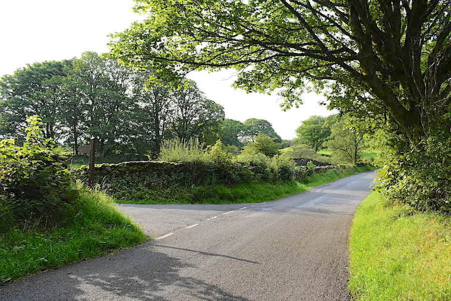
Arriving at the High Borrans turn off from the parking area at Moor Howe. We got to Moor Howe at 8.00 am to make sure we could park up easily, even so a couple of vehicles were already there and their occupants nowhere in sight. Its a warm and sunny morning, there’s a light breeze and a few clouds drifting around. The breeze and the occasional cloud cover were more than welcome as the sun rose higher and the temperature began to climb.

An early morning view across the fields towards Sour Howes from the High Borrans road.

One of the handful of residences at High Borrans.

The road off to the right leads down to another private house so we keep straight on and pass through the gate.

We leave the lane a little further along and pick up the footpath beyond this gate. The lane carries on to another private residence, High House. The route across the field is indicated by marker posts carrying the familiar yellow arrow signs so route finding is not difficult.

The route across the field paths eventually brings us out at this point, where it meets the Ings – Kentmere bridleway. We’ve just come through the gate in the centre of the shot and will pass through the gate on the right and head north on the Kentmere section of the bridleway.

From the gate the grassy pathway leading over to Kentmere.

Another junction so, after passing through the gate on the left, we now go though the gate on the right still heading towards Kentmere.

Sour Howes and Sallows eventually come into view as we walk through the open countryside via the path from the gate. Mickle Moss is over to the right of us.

Sallows ahead, the sun is shining, the heather is in bloom and everything is verdant and lush. What’s not to like? When we reach the green fields on the right of the shot we’ll leave this path and make our way over to the top of Sallows.

A look back at the stepping stones across a small beck. There is a ford crossing just out of shot on the left but the water level was too high to use it today, thanks to a couple of recent thunderstorms emptying their contents all over us.

We left the bridleway here and made our way over the fields up to a fence line. Here’s a look back towards Sour Howes from the bridleway.

The gate in the fence was padlocked so we climbed over it to reach the open fellside. From there I took this view across the fields along the Kentmere valley.

We’re beyond the fence line now and making our way around Mould Rigg over towards the line of outcrops across the centre known as Scour Rigg. We skirted around the edges of the flatter area as some parts of it can be rather squelchy.

Rounding Scour Rigg now and heading up towards Sallows. The tree topped fell on the left is Sour Howes. We didn’t find much in the way of an established path across here but there were plenty of sheep trods to use.

A closer look at Long Crag, the line of outcrops rising up the centre of the shot, on the Kentmere Park side of Sallows.

Out of nowhere this narrow path turned up as we headed over towards Long Crag. Notice how the bracken is beginning to go over.

A look back at Scour Rigg from the path leading us towards Long Crag.

This is the view from the little path below Long Crag, the Kentmere valley is on the right and above the flatter marshy area on the left are the rocky tops of Mould Rigg. As often happens the little path suddenly vanished so, having rounded the last bit of Long Crag, we were on rougher ground again, even the sheep hadn’t bothered to leave a trail, so it was somewhat rough on the feet and ankles and just as the heavy lifting began. On the plus side though the breeze and some occasional cloud cover kept us cool.

Almost hidden in the long and coarse grass is a line of grouse butts although the state they were in suggested it was a long time since they had been used for that purpose. This was the first one we came across and it came in handy as foreground interest for this shot across Crag Quarter and Kentmere to the ridge line of Harter Fell, Kentmere Pike and Shipman Knotts. Just beyond the butts I noticed what looked like quad bike tracks so we followed them which made things much easier on the feet and ankles.

Higher up and close to the quad bike tracks were other grouse butts, here’s a view down to three of them.

A look back at our route so far. Over on the right are the green fields we crossed to reach the fence line, to the left of them you might just be able to make out the two tops of Mould Rigg in the centre, over on the left is the dark bump of Scour Rigg, and just below us, to the right of the grouse butts, are the humps and bumps of Long Crag.

Across the valley is Kentmere village and behind it the emerald green pastures of Green Quarter Fell.

Still following the quad bike tracks and climbing higher with a view along the Kentmere valley. Nothing much to see beyond that as the haze is quite bad.

The summit of Sallows finally comes into view, as does that of Red Screes just peeping up over on the right.

Another view of the summit with the Coniston Fells and the Scafell group behind it to the left.

We haven’t met anyone on the way up here, there’s no-one else at the summit, and no sign of anyone walking over on Sour Howes either. We take advantage of the peace and quiet to have a short stop for drinks and snacks and just enjoy the view over to Sour Howes and Windermere.

On our way again now and leaving Sallows with a view of Yoke, where we walked a couple of weeks ago, immediately ahead of us.

Turning down towards Sour Howes with Wansfell across the middle foreground and the Scafell group on the skyline.

The Coniston fells ahead as we drop down to the wall and the stile crossing.

Dappled sunlight on Red Screes and St Raven’s Edge.

A last look towards Crag Quarter and the Harter Fell – Shipman Knotts ridge line before the view is lost.

A burst of sunlight lands on St Raven’s Edge and neighbouring Woundale and, towards the bottom right of the shot, Troutbeck Tongue also gets a share of it.

Down at the stile where we have just met the second walker of the day. The first one, the lady’s husband I presumed, we had already met about a hundred yards back up the hill. Both were hot and bothered with very shiny faces. We don’t have any breeze at the moment as the mass of Sallows behind us is blocking it and its very muggy along here. We had shiny faces too and we were only going downhill.

Heading over to Sour Howes alongside the wall. Its often very mushy along here and the recent downpours have added to the mushiness.

The view along Troutbeck to Froswick, Ill Bell and Yoke where we walked a couple of weeks ago, that was a hot and humid day too.

Red Pike on the left skyline with a sunny St Raven’s Edge below it. Caudale Moor on the right looking very sombre under the cloud cover.

Up on Sour Howes now with a look back along the Troutbeck valley. The white buildings of Troutbeck Park farm are just peeping up at the end of the valley.

Crossing the undulating top of Sour Howes and still no-one in view. Everybody must be having a lie-in.

The top of Sour Howes looking towards Red Screes …..

….. and then looking towards the Troutbeck valley.

Windermere, but not much else, from the summit.

The view is slightly clearer across to Sallows. We had another stop for refreshments on Sour Howes although it was more to do with sitting in the sunshine and enjoying the views than needing something to eat and drink.

Heading down from the summit and we spied a lone walker just disappearing over the stile in the wall ahead.

Everything is very hazy beyond Windermere.

Looking back along Troutbeck.

Over the stile and …..

….. down over Backstone Barrow towards the Dubbs road. Dubbs reservoir has come into view over on the left.

One of the rock tors on Backstone Barrow. We have lost the breeze completely now and there’s not much cloud cover so we’re beginning to get rather warm. Beyond the outcrop we met a family coming up. Mum and Dad and three children. The eldest, a girl of about twelve or thirteen, was really having a struggle getting up the path while her two much younger siblings seemed to be taking it very much in their stride. You would have thought that quite the opposite would have been the case.

Down to the Dubbs road at last and we can take the brakes off the legs and have a relaxing walk back to the car at Moor Howe.

Dubbs reservoir comes into view. It felt as though we were being incinerated as we walked along the lane and the sight of forbidden water didn’t help matters! We soaked our neck scarves in every beck we came to. Thankfully there were plenty of becks and streams along the lane so we were able to cool down along the way.

I tormented myself a bit more by peeping over the wall for this view looking back along the reservoir.

A startling blaze of crimson crocosmia at the side of the lane. I wish the crocosmia in our garden was as tall and abundant as that.

A look back along the Dubbs road as we near the end of it.
 Its just past one o’clock, there’s no breeze at all down here, the sun is blazing and J hugs the shade as he approaches the car at the end of the Dubbs road. I expected to see a bit of a log jam of cars parked any old how when we got back but only one other car had arrived since we left and the place was deserted. It was a completely different kettle of fish as we drove home. Troutbeck, Kirkstone, Patterdale, Glenridding, Ullswater and Pooley Bridge were all bursting at the seams with cars, camper vans, large motor homes, motor bikes, cyclists, pedestrians, dogs, canoes, kayaks, paddle boards and no doubt lots of other paraphernalia which I didn’t spot at the time. All of that is to be expected on a hot summer’s day in the Lakes but what I didn’t expect to see was a walker setting off on his walk complete with one of those hideous black muzzles across the lower half of his face. Regular visitors to this site might by now have some understanding of my views on the ludicrous situation this country is currently experiencing so I will not elaborate further on face muzzles. My suggestion, to anyone who cares to take notice, is to ignore any ‘invitation’ to take a test. If you aren’t feeling unwell there is absolutely no reason to do so. The testing programme is being maintained solely to find ‘cases’, maybe to justify further local restrictions or, which is very much more likely, a duplicitous attempt to cover various backsides. Cases have been more and more difficult to find as the weeks have gone by because the ‘great plague’ is over, as all the stats, charts and graphs are showing. So, if you want the restrictions gone and your life back in your own hands, just don’t take a test. Simples!
This link: https://off-guardian.org/2020/06/27/covid19-pcr-tests-are-scientifically-meaningless/?fbclid=IwAR3G6Fuq8C-8XW7szL43scbKOYFx78irq52A6ZQCRdZmPMWiHTqD_2jv4Zo explains why the ‘tests’ are of no value. Its a lengthy read but worth the effort. Now comes the unsurprising news that the Government has quietly removed 1.3 million tests from its database because of ‘double counting’ as reported here:
and here:
https://lockdownsceptics.org/2020/08/15
Its just one cock-up after another and the cracks are beginning to show.