
Selside Pike, Artlecrag Pike and Branstree
Walk date – 25th January 2021
Distance – 6.3 miles
Weather – dry with sunny spells, very windy
Ordinarily this is a fairly gentle and easy walk over a couple of grass covered fells above Haweswater. There are no rock walls, crags, or any other potential hazards to deal with along the route and probably the most troublesome thing any walker would have to deal with would be the Captain Whelter Bog after a period of heavy rain. Walking in snowy/icy conditions is always a tougher proposition than summer walking and with that in mind we decided on the Selside Pike to Branstree walk today. They provide enough height to still offer some snow walking with no very steep climbs over rocks and crags layered with snow and ice. We had planned to return via Branstree’s north ridge in order to enjoy the surrounding scenery on the return leg, and because that route comes to an end a hundred yards or so from the lay-by parking on the Haweswater road there’s not much road walking to be done. We abandoned that idea because we had had more than enough of the incessant and very strong west wind by the time we reached the summit of Branstree.
Route
Mardale – Mardale Banks – Old Corpse Road – Selside End – Selside Pike – Artlecrag Pike – Branstree – Gatescarth Pass – Mardale


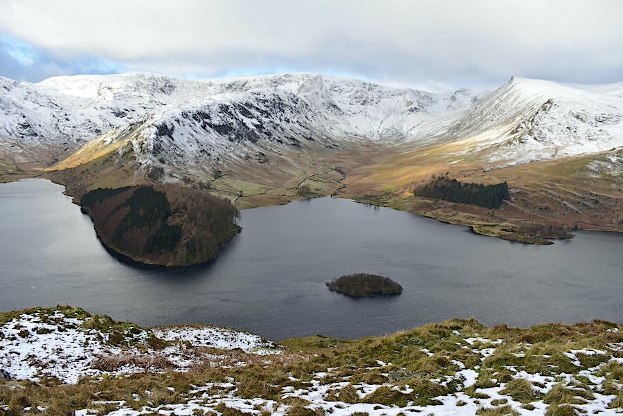
The view across Haweswater from the lay-by. There’s a slight breeze and lot of big cloud around but brief patches of sunlight appear now and again.

A look towards Mardale Head as we climb Mardale Banks. Less than a dozen cars today in the parking area at the end of the road.

Much higher now, just below the old peat huts, and where this neat little pyramid shaped cairn stands on a rocky plinth. We’re at the point where the views of Haweswater and its surrounding fells begin to disappear so I took a couple more before we went any further.
On the left is the promontory known as The Rigg, from which the Rough Crag/Long Stile route goes up to High Street. On the right, across Riggindale, is Kidsty PIke.

Harter Fell and Mardale Ill Bell on the skyline.

Looking across Haweswater from the first peat hut …..

….. and the same again, just a little further up, from the second peat hut.

We reach the flatter path above Mardale Banks and pause for a breather. Haweswater has all but disappeared from view but its a good place for a close up view of the Rough Crag/Long Stile ridge route. The slight breeze has now become rather stronger and more annoying.

The craggy face of Harter Fell dominates the head of Mardale, to its right is the north-east ridge of Mardale Ill Bell and between them is Smallwater Beck and the Nan Bield Pass.
Heading for Selside End along the corpse road. The path was very icy in places but was easily circumvented. The wind is becoming increasingly annoying and is blowing the soft powdery snow all over the place. Spindrift starts hitting our faces, not a pleasant experience.

A look back along our route when we reached the wooden post marking the path up Selside End. We got the coffee out and had a short break here, more for a respite from the wind than anything else, but it was pleasant enough to have our backs to the wind and our faces to the sun for ten minutes.

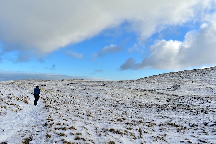
As we climb the long and gradual slope of Selside End the wind comes at us directly from the west, its speed gradually builds, constantly knocking us off balance, and its a battle to make progress. If its so strong at this level we can only imagine what it must be like on High Street, Kidsty Pike and High Raise over yonder.

High Raise, Low Raise and Whelter Crags from Selside End.

The Haweswater skyline. A lovely view of the fells around Mardale. A little further on a lone walker came by us. He did say something as he passed by but neither of us had the slightest idea what he said, his words were just drowned out by the noise of the wind.

A little diversion over to Low Blake Dodd for this view into sunny Swindale and …..

….. the view across Dodd Bottom towards the heavily iced Forces Falls.

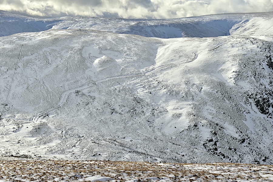
A short climb from Low Blake Dodd brings us alongside this tarn, frozen solid today. An extensive bank of heavy cloud obliterates views of the north Pennines.

Wind speed reading on Selside Pike. The forecast mentioned 15-25 mph at 850 metres which would at least have been somewhat more tolerable. Specks of spindrift still visible on the meter.

Selside Pike’s summit shelter, frozen snow inside and out and not much use today.
View back to Selside Pike. We’re using the lower path beside the fence line to cross over to Artle Crag and lots of deep drifts to contend with along the way.

This is the other only shot I took as we crossed from Selside Pike to Artlecrag Pike. We took the lower path from Captain Whelter Bog rather than cross the higher, and more exposed, ground of the nameless hill at 673 m. High Howes is our unofficial name for it. Even so it was a very rough crossing, the path had obviously been extremely muddy previously but was now frozen hard, badly rutted and very uneven. Add in the icy patches, the snow and the strength of the wind and it was more a case of enduring rather than enjoying. It was at this point we seriously considered calling it a day and making our way back over to Mardale Banks. However that would have meant walking straight into the wind and the spindrift, not a pleasant thought given how very unpleasant it was just being sideways on to it. It would also have involved a pathless descent over rough ground full of deep drifts and crossing a couple of deep and icy gills so, everything considered, we just carried on towards Artle Crag.

Constantly being punctured by spindrift and buffeted every which way made it hard going and tiring but we eventually got there. Still taking a battering by the wind I took a look back at our route – from Selside Pike, on the left, across the path by the fence line on the nameless hill and then the climb up to this point. In the summer its a very pleasant ramble over uncomplicated ground.

A further short climb takes us up to the two cairns on Artlecrag Pike where I took a look back .Selside Pike is on the left of the shot.

We staggered across to the circular trig point on Branstree only staying long enough to take a shot of it.

Crossing from the trig circle to the wall with a look across to Harter Fell and the fabulous cloud formations behind it.

Crossing the stile and following the wall over Selside Brow leads down into Mosedale. We follow the fence line down to the right and make our way down to Gatescarth Pass. We’re still being assailed by spindrift and consequently our faces turn redder after every onslaught.

Still taking a battering as we descend Branstree. There is no shelter at all across its wide open slopes.

Some of the wonderful cloudscapes taking place above Harter Fell. At least it took our minds off the battering we were getting.
Extra care needed down here where the gradient becomes more pronounced. Across the way we can see the path from the Gatescarth Pass leading up Harter Fell.

The gradient becomes easier as we approach Gatescarth Pass …..

….. and when we reach it we put the microspikes on. The surface is gravelly/stony and water from nearby becks does tend to flow over parts of it from time to time so we know it’s likely to be very icy further down.

Kidsty Pike misses out when a splash of sunlight lands on Rough Crag during the descent.

We get a change of view further down when Haweswater comes back into view.

The wind, and the ice, let go of us as we reached the cross wall back there so we could at last hear each other speak. We haven’t had anything to eat since breakfast so we had a late lunch perched on one of the large flat stones to be found beside the path, just above the parking area. Nobody around in the car park and only eleven cars parked up. Out of the wind and with a view along Haweswater we tucked in to the soup and sandwiches.

With the fuel tanks re-filled all we had to do was take to the road alongside Haweswater and have a steady, and wind free, walk back to the car.

From the road a look back at the north-east ridge of Mardale Ill Bell …..

….. and a look ahead along Haweswater. Sunset is still a couple of hours away but the clouds behind and to the left of us have joined forces and that looks to be the end of the sunny spells for today. It would be nice to say otherwise but this wasn’t the most enjoyable walk we’ve ever done thanks to the strength of the wind which made everything much harder than it should have been. Having said that it didn’t rain, sleet or snow, there were some decent sunny spells and the views were as lovely as ever, so not too bad a day all things considered.