
Lingmoor Fell
Walk date – 17th December 2021
Distance – 7 miles
Weather – sunny and mild, no wind
Patience is rewarded, at long last, with what is forecast to be a period of settled weather over the next few days. Let’s just hope it turns out to be accurate.
Today we headed off to Elterwater to take a walk over Lingmoor Fell. We last visited Lingmoor in 2016, prior to that it was 2011 so today’s walk is entirely in keeping with our unintentional pattern of quinquennial visits. We parked up as usual in the Walthwaite Bottom car park on the fringe of Elterwater village. Apart from a bin lorry, parked with its engine running and the lads who do the heavy lifting sitting in the cab taking a short break, that was it. Even better, the ticket machine was out of order so the handful of £1 coins went back in the parking tin. A great start to a great day.
Route
Elterwater – Burlington quarry – Sawrey’s Wood – Banks Quarry – Lingmoor Quarry – Brown How – Birk Knott – Little Langdale – Sawrey’s Wood – Elterwater


The Britannia Inn, Elterwater. The remnants of an inversion were still hanging over the village as we made our way towards the bridge over Great Langdale Beck.

Once across the bridge we immediately turned sharp right and followed the road up the hill heading towards the Burlington quarry. The lingering inversion is subduing the sunlight and creating an eerie atmosphere.

Further along the road we veer off to the left and follow the quarry track. Doesn’t matter if you stay on the road as both tracks meet up just a little further along, taking the quarry track just cuts off the corner and of course it is much rougher underfoot than the smoother surface of the road.

Beyond the Burlington quarry the track carries on through woodland where there was plenty of evidence of the damage caused by Storm Arwen a few weeks ago. Someone had a wry sense of humour when they placed the red notice on one of the fallen trees: ‘Caution – Heavy plant crossing’.

Continuing on through the woodland…..

….. and a look back at the gently graded track as we round one of the many bends in it. We have climbed above the remnants of the inversion but now the sun is blocked by the hillsides above us.

We meet more Storm Arwen casualties to the right of the track as we continue to climb.

Huge mounds of quarry spoil line the track on both sides. Here’s a look back at some of them as we reach the flatter area at Banks quarry.

The inversion still lingers as we pause to take a look along Great Langdale from Banks quarry.

A closer look at Burlington quarry where its daily work was very much in progress, plenty of banging, clanking and thudding going on down there.

Part of the old workings at the now disused Banks quarry.
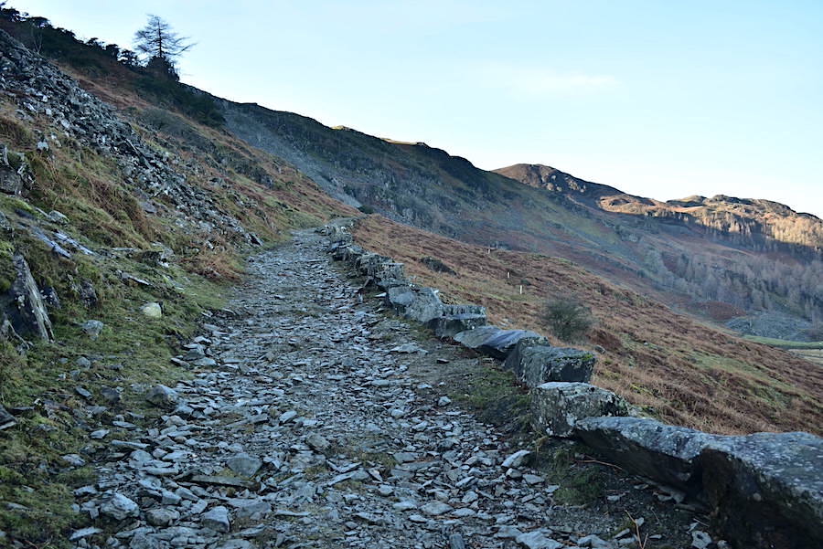
From the quarry we carry on up the track which is slightly less wide along here than it was lower down. The sunlight is still hidden behind the bulk of Lingmoor. Not that we minded as it was quite warm work and both of us have our jackets unzipped.

Looking back along the track at Burlington quarry and Great Langdale. Loughrigg takes centre stage across the middle foreground with Red Screes on the skyline to its left and Ill Bell and Yoke just behind it

Six runners came down the track on the left so we waited for them to pass by before turning up the stony path. The grassy track to the right was signposted ‘Private’, presumably to keep walkers from straying into the spoil heaps and the old workings of the disused Lingmoor quarry. They didn’t look very hospitable anyway so we didn’t bother investigating. The path to the left, signposted Lingmoor and Side Pike, leads up to a padlocked gate in the ridge wall across the fell which we climb over. Conveniently placed in the gate are some metal plates, in lieu of a stile, so its not difficult to get across.

Once over the gate and up onto the ridge we get our first burst of sunshine and a bird’s eye view of an inversion along the length of Lake Windermere. There’s some haze around so the long distance views were not so clear today.

From the ridge a look across Great Langdale towards the village of Chapel Stile nestled below the Blea Rigg/Silver How ridge. On the left skyline is the Helvellyn range, with Fairfield, Great Rigg and Heron Pike over to the right.

A russet coloured Dow Bank glows in the piercing sunlight across the middle foreground.

The mist still lingers below Loughrigg across the valley. Froswick, Ill Bell and Yoke occupy the right skyline.

We took a short break here for a quick snack and to take off our jackets. It was now very warm and the remainder of the walk to the summit of Lingmoor was done at t-shirt level. It felt like a warm spring day. Our onward route will take us along the diagonal path over to the rock outcrop on the right, from there the path veers upwards to the left.

We arrived at the viewpoint with the stone seat where Lake Windermere’s inversion was still very much in evidence although there were signs that it was beginning to fray a little around the edges. While we were here a youngish couple arrived, both wearing wellies, hardly the most suitable footwear for walking the fells. Neither of them carrying packs so they were probably visitors just having a short outing. They didn’t follow us along the route to the summit so perhaps this was as far as they were going today.

The stone ‘sofa’ and yes, of course we sat in it for a minute or two. Its only good manners isn’t it when someone has gone to all the trouble of creating it? That’s our excuse anyway.

Carrying on from the stone ‘sofa’ and after a few humps and bumps along the way we get our first view of Brown How, the high point over on the left and the summit of Lingmoor Fell.

Following the wall with a view of Crinkle Crags on the left and Bowfell over to the right.

Pike O’Blisco with Cold Pike behind it on the left.

We’ve reached a high enough viewpoint for a look back along the route so far. The stone ‘sofa’ is some distance away now on that middle ‘hump’ just below the Windermere skyline.

Still following the wall and still heading towards Brown How.

Approaching the stile just below the summit of Lingmoor Fell. Not a cloud in the sky apart from those chemical trails up there which were sprayed from ‘planes non stop during our walk. Don’t label us conspiracy theorists, several countries + NASA have admitted to doing this and it has been going on since the 1990’s and possibly even earlier.
https://principia-scientific.com/nasa-scientist-says-chemtrails-are-real/
Plenty of other articles are available if you choose to search for them. Google, Wikipedia and other similar sites will claim ‘conspiracy theory’ or won’t list them so do some research and make up your own mind.

The summit cairn against the spectacular backdrop of Pike O’Blisco, Crinkle Crags and Bowfell, the deep shadows emphasise the magnificence of the view.

The awe-inspiring Langdale Pikes dominating Great Langdale. Lunch break views don’t come much better than this.

The bump of Sergeant Man on the skyline with Lingmoor Tarn down below us together with …..

….. the view along the Lingmoor Fell ridge.

They are impossible to ignore so here they are again, together with a few more views along Great Langdale …..


After lunch we descended to Little Langdale via the Birk Knott path …..

….. which is something of a roller-coaster path where all manner of ups and downs test your legs and your patience!

From the top of one of the humps and bumps a look back to Brown How and the descent route from it.

Blea Tarn comes into view as we make our way down the rough path.

Looking across the burnished slopes of Lingmoor Fell for this view of the Pikes again.

After a rough descent it was a relief to have the firm surface of the Little Langdale road under our feet. The path ends/starts just this side of the Blea Tarn car park, behind the wall on the right, and plenty of cars were parked there as we arrived. With Blea Tarn in deep shade we didn’t go down to view it …..

….. because it was obvious that most of Little Langdale was now in the shade so we kept to the road to enjoy the sunlight that was still available.

The Pikes are high enough to catch the afternoon sun but the valley has no chance. Despite the shade it wasn’t cold down here so we didn’t need to put our jackets back on again.

Black Crag and Holme Fell still getting the sun while Little Langdale is displaying the beginnings of a potential inversion.

A look back at the mist beginning to form over Little Langdale Tarn as we approach the left turn into the lane which will lead us back to Elterwater.

Approaching Dale End farm with plenty of sunlight still lighting up the fells in the distance.

Heading down to Elterwater now along the rough track through Sawrey’s Wood …..

….. and finally back down to the bridge crossing into the village. The lights of the little cafe up ahead are twinkling in the dullness even though it is only mid afternoon. Ah well, there are only four more days to go before the winter solstice after which we turn the corner and the sun begins to set just a little later every day. As we pass the cafe one of the staff, just coming back in after a fag break, asks us if we want a coffee and some cake but we resist his offer and make our way back to the car. After we left Elterwater behind we had the sunshine back again for most of the drive back home. Hopefully we’ll have the opportunity to do another walk before Christmas arrives but in case we don’t we would like to wish everyone a very peaceful and a very Happy Christmas.