
Patterdale
Walk date – 15th August 2019
Distance – 5.5 miles
Weather – cool with a strong northwesterly wind to begin with, then warmer as sunny spells increased and the wind eased
A lot of water has flowed under the bridges in our neck of the woods since our last walk and the torrential rain and strong winds we’ve had during the last few days have kept us indoors ever since. Today’s walk was a last minute decision as a very windy, very cool and very rainy morning greeted me when I peered out through the blurry rivulets, cascading one after the other, down the windows. However, by late morning the rain had stopped, although the wind hadn’t abated one jot, and patches of blue could be seen between the lumpy grey clouds. We decided to wait another hour, have an early lunch and see how things had developed by then. In due course the patches of blue increased, the roads and pavements dried out, but the wind was still rattling through the trees and bushes so any thoughts of high level walking today were soon banished. A valley walk was the obvious choice and having walked through Grisedale just over a week ago we opted for a perambulation through Patterdale. Drinks and snacks were stowed in a pack, along with waterproofs just in case, and we drove over to Patterdale hoping the weather wouldn’t have changed its mind during our thirty minute journey.
Route
Patterdale Primary School – Side Farm – Rooking – Crookabeck – Beckstones – Hartsop – Cow Bridge – Low Wood – Deepdale Bridge – Patterdale Primary School


All the usual parking places were full when we arrived in Patterdale but the space in front of the primary school was completely empty. There are notices on the fence stating that its a no parking area and is for school use only. But, we’re in the middle of the six weeks school holiday period, the school is closed and the space is available for use so that’s where we parked. Once we were ready we walked back in the direction of Glenridding to the George Starkey hut where we turned right and walked across to Side Farm, side-stepping the mud and the puddles all the way along the farm’s access lane.

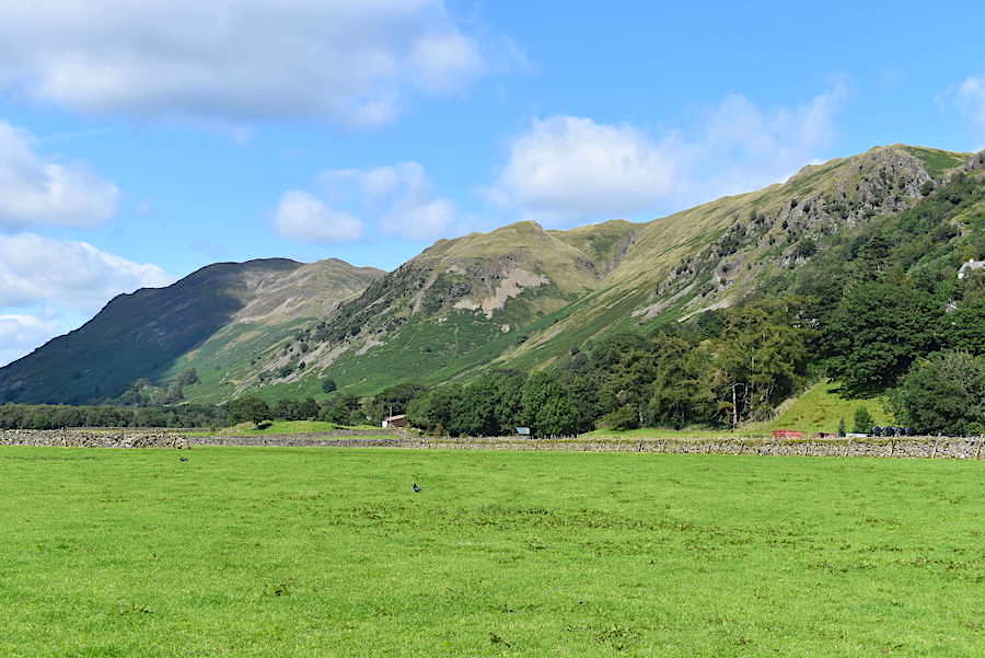
A look across towards Angletarn Pikes from the bridge over Goldrill Beck. The wind is roaring down the valley from the left of the shot and even though we’re wearing jumpers and windproofs we’re feeling pretty chilly along here. We’re hoping for some shelter in those trees once we’ve crossed this wide open stretch.

The farm’s camping site and shop are out of sight to the left of the shot but there was no-one around as we walked between the buildings and turned right onto the lane in front of the white house.

The lane rises gently from Side Farm and from one of its higher points I took a look across the fields to Birkhouse Moor and the Helvellyn fells which overlook Grisedale, where we took a walk ten days ago. Even down here we are still being blown to pieces so it wasn’t too difficult to imagine what the walking conditions up there would be like.

At the top of the incline, just above the farm buildings, the track levels out. The house in the shot is Side Cottage, one of several holiday rentals we passed along the way.
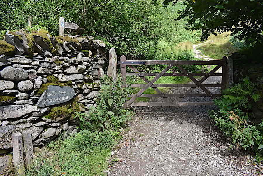
A little further along from Side Cottage we pass through a gate, out of shot to the left, and immediately to the left of it is this gate and the path leading up to Boredale Hause. We don’t turn up but carry straight on …..

….. to the path junction at Rooking. We turn left and carry on towards Hartsop, turning to the right would lead us straight back to the main road in Patterdale. It isn’t quite as open along here as it was back at Side Farm but the wind still gusts around us from time to time so we keep our layers on for the time being.

Walking through Crookabeck Farm. The notice by the gatepost is indicating the way to the Farm Shop which specialises in selling products made from the fleeces of their Angora goats and Herdwick sheep. We didn’t go in but it all looked very interesting and colourful when I took a quick peep as we passed by. They also have self-catering cottages and B&B accommodation, you can even buy a Herdwick sheep if the fancy takes you. I can still remember the Angora cardigan my mother knitted for me when I was about six, the wool was pale green, the fibres were fluffy and it was a very warm, yet really lightweight piece of clothing, which I loved wearing.

The path continues on from Crookabeck through some lovely woodland …..

….. where we are really sheltered from the wind and where my windproof and jumper just have to be removed. The sun blazed down from larger and larger patches of blue sky as the afternoon heat gradually burned off more of the cloud and walking along here was absolutely delightful. The U shape of the Kirkstone Pass comes into view above the tree line.

A look back at Place Fell as we leave the woodland and cross more open land. J has also succumbed to the sunny weather having stowed his windproof in the pack although he’s still wearing his thin fleece jumper. Mine was removed some time ago because I was getting much too hot in it. I can’t stand being muffled up but that doesn’t seem to bother J.

Passing the farm buildings at Beckstones and further on around the bend …..
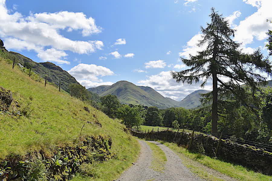
….. Hartsop Dodd, Caudale Moor and Red Screes come into view directly ahead of us.

The good track is a pleasure to walk over as it twists and turns, rising and falling gently along the way, with the trees constantly hiding and then revealing the views as we head for the gate below Lingy Crag on our way to Hartsop.
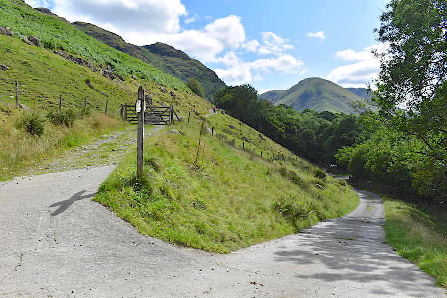
Closer to the gate and at another path junction. Going down to the right leads down to the bridge across Goldrill Beck and then along the field path to Deepdale Bridge and Bridgend back down in the valley bottom. We follow the upper path on the left and carry on through the gate towards Hartsop.

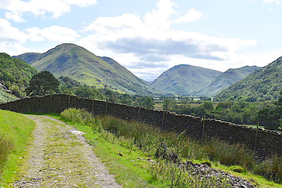
A look over into the long, and mostly hidden, valley of Deepdale from the upper path. The extensive ridge of Hartsop above How is over on the left, Hart Crag and Fairfield are occupying the centre skyline, with the pointy top of Gavel Pike, below Saint Sunday Crag, over on the right.

Further along is another junction which only becomes obvious once you are alongside it so this is a look back. This also leads, quite steeply in places, up to Boredale Hause. We don’t turn off here either and …..
….. continue to walk the gentle path where a smidge of Brothers Water can be seen just above the top of the wall.
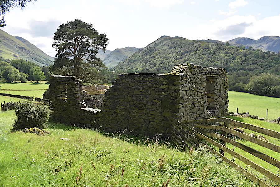
A derelict building standing just below us at a bend in the path a little further along, with the tree covered slopes of Hartsop above How right behind it.

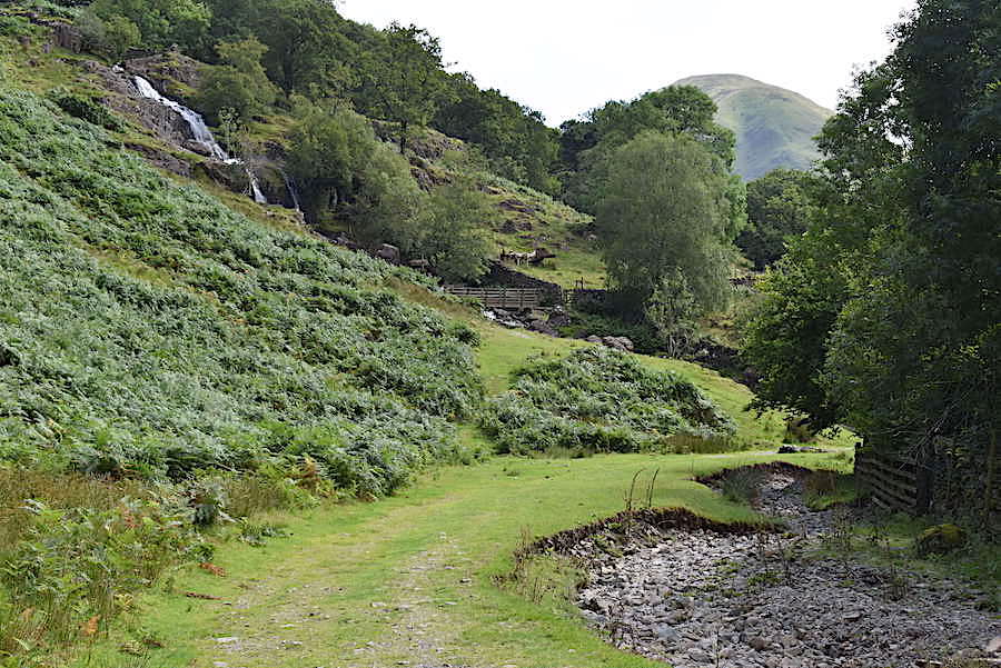
The beck crosses the path for a short distance at this point but the water level was quite low today so it was just a case of splashing through it. If its in full flow then the bridge comes in handy and the path from it links up with the one on this side just a few yards further along. Below the trees on the left are the waterfalls of Angletarn Beck which could be heard very clearly as we approached.
Two bridges cross the beck, the upper one can be seen in the shot while the lower one is out of sight around the bend in the path. Whichever bridge is used the paths beyond them each lead on to Hartsop. The bridges were damaged and/or dislodged during Storm Desmond and were out of action for a while but everything is back to normal now.

Approaching the upper bridge with the path continuing across it and on through the gate. Before going across I clamber up the wet, muddy grass and over the slippery rocks for a shot of …..

….. the upper set of falls which were thundering down over the rocks much to the excited delight of one young lad coming across the bridge with his mum and dad. It must have been a thrilling spectacle for a five or six year old as he looked up, squealing with joy, at the sight of it. A lovely silver lining to all the cloud and the rain we’ve put up with lately, and to see and hear him viewing it all so excitedly was lovely.

I couldn’t quite get the lower and upper falls in one shot so I clambered and slithered my way back down to the bridge for this shot.

Looking back along Patterdale, and the path we’ve just been walking, from the bridge. The little lad is still hopping around gleefully just below it.

A longer look along the valley on what turned out to be a really warm and sunny afternoon.

We go through the gate by the bridge and over the trees on Hartsop above How I took a closer look over to Gavel Pike and Saint Sunday Crag …..

….. and a look back for a close up shot of Place Fell and Angletarn Pikes.

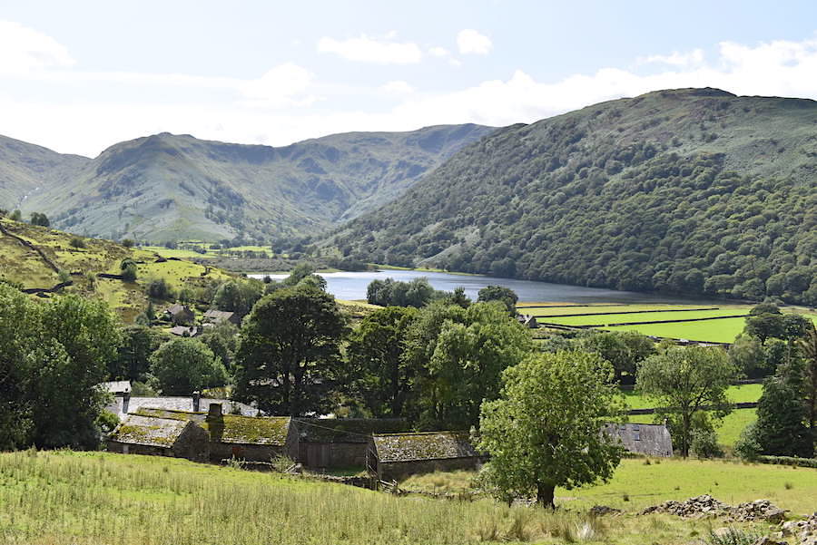
At another junction we get a better view of Brothers Water and its surrounding fells. At this point we turn up to the left and follow the now concrete path …..

….. where a break in the wall provides a good view of Hartsop Dodd’s very, very steep northern ridge.

The concrete path eventually turns into this grass and gravel one from where we get a glimpse of Gray Crag just behind the trees and …..

….. a little further on a clearer view of it and Thornthwaite Crag on the skyline. Beyond the gate the track morphs into twin ribbons of concrete with a grassy middle which remains with us as we walk the short distance into Hartsop village.
Another view of Brothers Water across the rooftops of Hartsop which we seem to have arrived at in no time at all.

There’s an abundance of phone wires above the village and taking a shot without them appearing in it was unavoidable. They’re not very pretty to look at but obviously necessary as mobile phone signals can often be non-existent or patchy, at best, around the Lakes.
More wires cluttering the view of the track down into the village at the point where we had a short break for drinks and J attacked a Mars Bar.

Down in the village after our thirst quenching stop and a view of one of the houses with a spinning gallery. Apparently Hartsop used to be an important centre for wool spinning in mediaeval times.

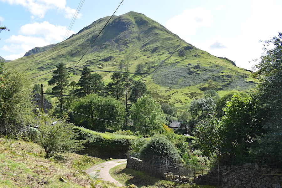
We leave Hartsop and walk down the lane to the main road through the valley where Arnison Crag is under a cloud at the moment.
The busy road does have a pavement so we can avoid the traffic as we walk along to Cow Bridge. As we did so I took this look across the valley fields over to Place Fell, Angletarn Pikes and Lingy Crag.

A look back at Hartsop Dodd, with Caudale Moor behind it and Red Screes over to the right, as we cross Cow Bridge and …..

….. go through the handgate directly opposite. The gate on the left leads to the path alongside Brothers Water.

We turned right after going through the gate where we had another lovely walk through Low Wood.

The path runs alongside the main valley road so both walkers and drivers are able to pass safely and easily along Patterdale.

The stepping stones were very welcome this afternoon, without them boggy boots would have been unavoidable. The woodland path goes up the little bracken covered rise and then drops down and deposits us at the roadside, but …..

….. the verge is wide enough to accommodate walkers quite safely and without any need to walk the tarmac. There’s another mile of walking, before we reach the school, from the point at which we began to walk alongside the road. The wind has eased off and its now very warm in the valley bottom so J finally gives in and removes his mid-layer. Another unavoidable phone wire dangles above us.

A look across to Boredale Hause, between Place Fell and Angletarn Pikes, as we walk back towards Patterdale …..

….. and a look back to Thornthwaite Crag, Hartsop Dodd and Caudale Moor. The grass verge path eventually petered out but we weren’t left at the mercy of the traffic. Footpaths were available all the way back although we did have to cross the road several times before we could set foot on them.
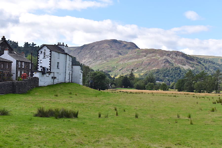
We’re back in Patterdale where the white walls of The White Lion stand out against the backdrop of Sheffield Pike and Glenridding Dodd and where the pavement peters out once more.

The pavement disappeared completely where the road narrows and winds its way between The White Lion and the buildings opposite, so to avoid the traffic we threaded our way through the car park opposite The Patterdale Hotel and from it we can see the primary school where we are parked, plus two or three others who have parked there since we left. What a really lovely and very enjoyable little walk we’ve had, made all the more so because it was an unplanned, spur of the moment excursion thanks to the weather bucking its ideas up. We’ve only been out for two and a half hours and we’ve sauntered rather than walked in order to prolong the walk and make the most of the lovely weather, and we met quite a number of others along the route all taking full advantage of this unexpected little bonus of a dry and sunny afternoon.
N.B. I prepared this walk report today, Friday 16th August, and all day we have had rain and strong winds so the summer looks to be back on hold once again.