
Walk date – 8th July 2025
Distance – 5 miles
Weather – sunny with light breeze, very warm, hazy
Having read through all the various forecasts for this week we came to the conclusion that today seemed most likely to promise some sunshine and light winds so we decided to pay a visit to Seat Sandal which we haven’t set foot on since 2017. Despite setting off in good time we were brought to a standstill when we reached the roundabout just up the hill leading out of Eamont Bridge. I don’t know what caused the hold up but only when we were past the J40 roundabout crossing the M6 and on the A66 were we on our way again. Traffic was flowing freely on the M6 so that couldn’t have been the root of the problem so it must have been caused by an incident on one of the roundabouts. The delay was considerable and we began wondering if we would find a parking space in the lay-by on the A591, just above High Broadrayne, where we had planned to park. When we reached it we were relieved to find that it wasn’t full and we had no problem parking even though there were a few cars already parked there. When we were ready to go we walked down the hill towards Mill Bridge where the footpath for Seat Sandal begins. It was a lovely sunny morning and already quite warm so the light breeze which cropped up from time to time was very welcome.
Route
Lay-by on A591 (north of High Broadrayne) – Mill Bridge – footpath to Tongue Gill footbridge – Tongue Gill footpath – Grisedale Hause – Seat Sandal – Mill Bridge – Lay-by on A591


Having walked down the hill from the lay-by we reached the start of the footpath leading up to Seat Sandal. The shot above is looking up the A591 from our turn off point and shows Steel Fell. On the road below it a car is just disappearing which I thought had already done so. So much for waiting for a break in the traffic!

Looking in the opposite direction now to where a signpost indicates the start of the path.

We pass the houses at the start of the rough track and begin the steady climb up to the footbridges crossing the two becks of Little Tongue Gill and Tongue Gill. A section of wall collapse along the track provided a good view of Helm Crag.

The walk up the track, enclosed by a high wall on one side and woodland on the other, was very muggy and we were relieved to be back out in the open again when we reached the end of it. The water level was low enough to have used the stepping stones but today we crossed the beck via the footbridge. Walkers wishing to ascend Seat Sandal via the Little Tongue Gill route will need to follow the path leading through the bracken on Great Tongue which can be seen just behind the bridge.

Once we were over on the other side I took a look back to where the waters of Little Tongue Gill and Tongue Gill meet and become one beck. This then runs beneath Mill Bridge and flows into the river Rothay just below Helm Crag.

Having crossed a second bridge we made our way towards the path above Tongue Gill leading up the valley to Grisedale Hause. Just after crossing the second bridge I took a look up Tongue Gill towards the sheepfold/washfold on the banking just above it. We removed our mid-layers at this point in readiness for the steady climb ahead.

Several becks flow down the slopes of Great Rigg across the path and here J is waiting in case I needed a helping hand. All the boulders were wobble free so I didn’t need one on this occasion.

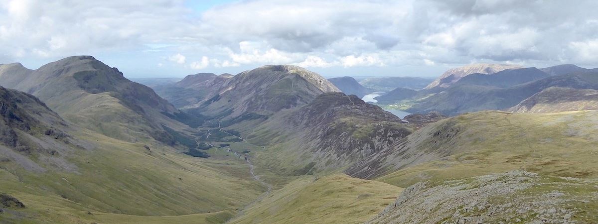
A look up the valley towards Grisedale Hause. Tongue Gill trickles down between us and Great Tongue, which was well covered in bracken, with Seat Sandal behind it. Over on the right are the steep slopes of Fairfield. The path across Great and Little Tongue is on the other side so it can’t be seen from this angle.

A pause to wipe the sweat from our faces and have a drink so I took a shot looking back towards Helm Crag and also our route so far. We are steadily climbing and the light breeze comes and goes. Its very welcome whenever it decides to put in an appearance, and very warm when it doesn’t.

Tongue Gill seems to have every type of water feature along its course, waterfalls, waterslides, cascades, plunges etc. Some were too far away to photograph satisfactorily but this waterfall showed up quite well although the camera was on maximum zoom at the time.

Here are a couple more – the one on the left has split into two sections each of which plunge onto the rocks below while the one on the right has split into three separate parts each of which slide over the rocks before joining up with each other again. We did spot a very pretty cascade too but it was too far away and partially hidden by the slope so I didn’t bother taking a shot of it.

After a short but steep climb up the pitched path we reach the waterfall area below Hause Moss where I stepped away from the path to take a look down at it as it crosses the beck …..

….. and the path from it leading up to the Hause. The walkers on the path ahead have joined it from the Hause Riggs path which we spotted them walking across earlier. That means that they must have taken the path over Great Tongue and then Little Tongue to reach Hause Riggs. We’ve used that route in the past and its quite a steep climb until the flattish path across Hause Riggs is reached. They were walking quite slowly and so were we as it was becoming very warm by now. I was sweating so much my specs kept sliding down my nose so I took them off and managed without them …..

….. behind me is the spectacular waterfall dropping its contents from Hause Moss into a little beck which tumbles down a short distance before joining Tongue Gill. Strictly speaking I suppose I shouldn’t call it a waterfall because it never loses contact with the rocks it flows over so its more of a slide than a fall but I’m sure viewers will know what I mean.

Having climbed steeply out of the valley it is now with aching legs that we face another climb up to the Hause although initially the path is quite gentle. I concentrate on the rocks and boulders strewn all around us in an attempt to take my mind off things. It didn’t work!

We’ve just had a chat with one of the two chaps just below us. I jokingly asked the chap bending down if he could have a word with Fix the Fells about installing an escalator rather than just repairing the path. He said, with a smile on his face, he’d see what he could do about it. I’m not expecting one to have been installed when next we come this way. The pink item nearest the camera is a Fix the Fells collection box so J dropped a coin into it. I expect it will be put to good use eventually. Looking back along the path I counted eight people on it, all of whom were walking slowly which is hardly surprising given the steep climb out of the valley which can be seen at the far end of it.

We’ve reached Grisedale Hause so we made straight for the old shelter, which can be seen just beyond the gap in the wall, and flopped down in it to take a break before tackling the rough path up to the summit just beside it. Chocolate bars and drinks were brought out and consumed as we watched the other walkers arrive at the Hause. Only one walker went down to Grisedale Tarn, everyone else, after taking a look down at it, turned right and began the steep climb up the Fairfield path.

After our break we set about climbing the very loose path from the shelter up to the summit of Seat Sandal. I took the above shot of Dollywaggon Pike just as we were about to leave. The first bit of the path is very loose and rough but it eventually leaves all that behind and becomes an intermittent gravelly path which winds its way steeply through the various rocky sections. However, in places its more of a scramble than a straightforward walk and in such places the rocks provided useful handholds from time to time.

Part of the way up the path there is a lovely view of Grisedale Tarn and Dollywaggon Pike. The view stretches along Grisedale and includes Place Fell, a smidge of Ullswater with Gowbarrow and Great Mell Fell at the end of it.

There’s also a great view of Saint Sunday Crag and Gavel Pike (on the left), Cofa Pike and Fairfield (on the right) plus the path leading from the Hause up to Fairfield. We could see tiny figures spread out along the path slowly plodding their way up and it must be one of the toughest routes walkers can choose to take up to the summit of Fairfield.

A little higher up the path from where I took a close up shot, on maximum zoom, of the view along the Grisedale valley. Place Fell is on the right at the end of it, a little smidge of Ullswater can be seen and, providing a big full stop towards the left are Gowbarrow Fell and Great Mell Fell.

The climb through the rocks comes to an end and we emerge onto the grassy path leading over to the summit of Seat Sandal. After the rough and stuffy climb up it was great to feel the breeze again and walk across the springy grassy path.

Once on the grassy path I took another look back towards Saint Sunday Crag and Gavel Pike (L) and Cofa Pike (R). Walkers on the path to Fairfield are now mere dots and difficult to see, even with my specs which are now back on.

The shelter on Seat Sandal with Great Rigg, on the right, behind it. We didn’t use the shelter but walked on to the summit cairn just a short distance further along.

Four bodies of water are on view from Seat Sandal summit, below us is Grasmere, above it to the left is Windermere and above it on the right is Coniston Water. That’s only three and having said four I’ll leave it to viewers to spot the fourth one which is called Alcock Tarn.

The summit cairn on Seat Sandal with a view of the tops of Saint Sunday, Gavel Pike, Cofa Pike and Fairfield. We had a longish break here to have something to eat and a drink of coffee but mostly to give our legs a good rest. They’ll need a rest before tackling the steep descent where the brakes will need to be kept firmly on.

The Helvellyn range beyond the summit cairn before settling down and taking a break, followed by the usual skyline shots from the summit …..

….. the Coniston fells …..

….. Crinkle Crags, with the Langdale Pike just below them, and Bowfell …..

….. Bowfell, Scafell Pike and Great End …..

….. three of the big ‘uns – Great End, Great Gable and Pillar behind Greenup Edge …..

….. from L to R – Dale Head, Hindscarth, Grasmoor, Crag Hill and Grisedale Pike …..

….. Grasmoor (L) over to Grisedale Pike (R) with all the usual fells between them …..

….. High Seat, Bleaberry Fell and the Skiddaw group …..

….. after which we come full circle back to the Helvellyn group.

After packing everything away we began the descent where immediately below and opposite us is Steel Fell.

The descent is gradual to begin with but steepens more as we descend and the brakes are applied accordingly. The vale of Grasmere is still a long way below us.

Lower down and a good view of Helm Crag appears. Below it is the wooded area around Helmside and between the two is the Greenburn valley.

Still having to keep the brakes on and grit our teeth as we head down towards the lower hill below. Both of us were looking forward to reaching a flatter path even if it would only be a short one.

We reached the lower hill and with legs wobbling like jelly I took a look back up the path we had just come down. By heck, that’s a steep one.

Obviously we still had to keep going downhill but the brief respite was more than welcome. At least the woodland alongside the path coming up from the Mill Bridge area is in sight at last. I was hoping that the twinkling windscreens of the line of cars parked up in the Grasmere lay-by below us would show how sunny it was but somehow the camera has failed to capture the sight so perhaps it automatically compensated against the brightness.

Still descending but we have a pleasant grassy path to follow and the route isn’t quite as steep as before.

With legs still wobbling we make for the gate below where we’ve decided to take a few minutes break and …..

….. after passing through it and taking a short break by the wall we continued on and had a pleasant walk down a much gentler path through the fields. I took a look back at Seat Sandal before we lost the open view of it.

A turn in the path brought us this view of Helm Crag and Gibson Knott before it turned again and …..

….. led us down to a gate in the wall on the left where the path back down to the houses below can be seen.

Having passed through the gate and back on the path again I took another look back to Seat Sandal.

At the end of the lane are the whitewashed Tongue Gill cottages so all we have to do now is turn right and walk the short distance back up the A591 to the lay-by …..

….. from where I took this last shot of Seat Sandal and also managed to include vehicles on the A591 yet again when I thought I had managed to exclude them! So that’s today’s walk over and done with and given the warmth of the day its been quite a rigorous one even though we’ve only walked a few miles. It has definitely given our legs a good work-out and they only stopped wobbling when we finally got in the car and sat ourselves down. The long distance views were poor in today’s hazy conditions so why do the weather forecasts continue to indicate that visibility would be ‘excellent’ when we can see for ourselves that it isn’t? Something to ponder upon perhaps.


 ….. I included it in this shot. I think the average time to walk the horseshoe is about six hours but of course the length of time it will take will always be dependent on individual rates of walking, ground conditions, weather, stops to remove or add clothing, take photos, and have breaks for all manner of other reasons. It really doesn’t matter how long it takes anyone to complete the horseshoe, simply view and enjoy the wonderful scenery around you and forget about the time because that’s what it is really all about. We last walked the Coledale Horseshoe on 10th June 2015 if you want to see what it entails before attempting it. I remember being quite weary when we got back home and we were both ten years younger then so we probably won’t be doing it again no matter how good the weather might be.


